Malta

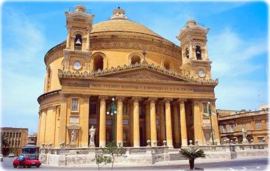
Mosta Church (the Rotunda) with the third largest dome in the world. Built between 1827 and 1865, and designed by Maltese architect Giorgio Grognet de Vasse.
Geography
Administrative divisions: 68 localities. The capital is Valletta.
Total area: 316 km². The country comprises an archipelago, with only the three largest islands (Malta, Ghawdex or Gozo, and Kemmuna or Comino) being inhabited; numerous bays provide good harbors. Coastline: 196.8 km (does not include 56.01 km for the island of Gozo).
Terrain: mostly low, rocky, flat to dissected plains; many coastal cliffs. Highest point: Ta'Dmejrek 253 m (near Dingli).
Climate: Mediterranean with mild, rainy winters and hot, dry summers.
Ports and harbors: Marsaxlokk, Valletta.
People
Population: 449,043 (July 2018 est.).
Religions: Roman Catholic (official) more than 90% (2006).
Ethnic groups: Maltese (descendants of ancient Carthaginians and Phoenicians with strong elements of Italian and other Mediterranean stock).
Language: Maltese (official) 90.1%, English (official) 6%, multilingual 3%, other 0.9% (2005).
Main source: CIA - The World Factbook.
Malta (local: Repubblika ta' Malta) is an island country in the Mediterranean Sea, south of Sicily. The capital is Valletta.
Great Britain formally acquired possession of Malta in 1814. It attained independence in 1964 and became a republic a decade later. Since about the mid-1980s, the island has transformed itself into a freight transshipment point, a financial center, and a tourist destination. In 2004, Malta became a member of the European Union. More: Map of Malta ►
|
Copyright © Geographic Guide - Travel European Continent. |


Valletta, capital of Malta.
Malta