
Map of Hawaii
Hawaii is a U.S. state since 1959. The archipelago in the Pacific Ocean has eight main islands: Niʻihau, Kauai, Oahu, Molokai, Lanai, Kahoʻolawe, Maui and the Island of Hawaii. The capital is Honolulu.

Lava formations in Halemaumau, Hawaii Volcanoes National Park. The Hawaiian Islands are at the southeastern end of a chain of volcanoes in the Pacific Ocean. It began to form more than 70 million years ago.
Waipio Valley in the Big Island.
Honolulu
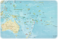
U.S. Territories in Oceania
Guam, USA


|
Copyright © Geographic Guide - Travel Pacific Islands. |


Source (edited): U.S. Geological Survey.