Map of Swaziland

 Swaziland is a country southeastern Africa. Lobamba is the
royal and legislative capital and Mbabane is the administrative capital.
The mountainous western portion in places reaches an altitude of more than 1,200 m above sea level. The hilly central region has an average elevation of about 600 m. The eastern region is a rolling area that averages from 120 to 300 m above sea level. It is bounded on the east by the Lebombo Mountains.
The principal rivers are the Komati, Lusutfu, and Umbuluzi. The steady flow of the rivers, fed by abundant rain in the mountains, supports irrigation and hydroelectric power projects in the lowlands. The country also has quantities of several valuable minerals, including coal, asbestos, diamonds, and gold.
The climate is mostly temperate, with cool temperatures at higher elevations and more tropical weather in the low veld.
Nearly all of the people in Swaziland are ethnic Swazi, although there are small populations of Zulu, Tsonga, Asians, and Europeans. The earliest known people in what is now Swaziland were the Ndwandwe, who lived in the southeast. In the 18th century the Ndwandwe defeated the Ngwane people, who had entered the region from the south. The Ngwane settled in the southwest, and warred periodically with the Ndwandwe. The early 19th century was marked by a prolonged series of local wars, centering around the powerful Zulu to the south. Ngwane leader Sobhuza led his people to higher elevations around 1820 to escape Zulu attacks. In this period the Ngwane became known as the Swazi, and Sobhuza established the Swazi kingdom in what is now central Swaziland.
When European settlers entered the area during the 1880s, the Swazi granted concessions to them that endangered the independence of the territory. An Anglo-Boer convention of 1894 placed Swaziland under the administration of the Union of South Africa. Administration passed to the British governor of Transvaal in 1903 and to the British high commissioner for South Africa in 1907. In 1967 Swaziland became internally self-governing. The nation attained full independence in 1968.
Swaziland has 294 km of railroads, linking it to the ports of Maputo in Mozambique and Richard's Bay and Durban in South Africa. The road system extends 3,107 km. The country's only large airport is at Matsapa, near Mbabane.
Maps of Border Countries: Mozambique and South Africa.

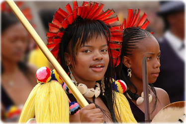
Princess Sikhanyiso Dlamini (left) at the Reed dance festival in Swaziland, in 2006. Royalties of Swaziland can wear red feathers in their hair.
◄ Africa
|
Copyright © Geographic Guide - Travel, African Continent. |
