West Region of Africa
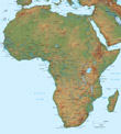
◄ Africa
Main cities of the region: Malabo, Abuja, Dakar, Banjul, Bissau, Accra, Freetown (Benin) and Bamako.
Maps the Countries Benin Burkina Faso Cameroon Côte d'Ivoire Equatorial Guinea Ghana Guinea Guinea-Bissau Gambia Liberia Mali Mauritania Niger Nigeria Senegal Sierra Leone Togo
Maps the Countries
Benin
Burkina Faso
Cameroon
Côte d'Ivoire
Equatorial Guinea
Ghana
Guinea
Guinea-Bissau
Gambia
Liberia
Mali
Mauritania
Niger
Nigeria
Senegal
Sierra Leone
Togo
Copyright © Geographic Guide - Travel, African Continent.
Map base: United Nations.