Map of Antigua and Barbuda
Antigua and Barbuda is an independent country located in the Antilles, Caribbean Sea. It comprises three main islands: Antigua, Barbuda and Redonda.
Antigua and Barbuda is one of the more prosperous of the Caribbean nations. The islands attract hundreds of thousands of tourists each year, and the nation’s economy is dependent on tourism. Antigua’s beaches are noted for their beauty. Cruise ships sailing the southern Caribbean often dock at the island. Numerous coral reefs and sunken ships surround Barbuda and Antigua, making for great snorkeling and diving.
Europeans first visited the islands when Christopher Columbus landed in 1493 on his second voyage to the America. These islands were British colonies from 1632 until they achieved independence in 1981.
More about Antigua and Barbuda ►

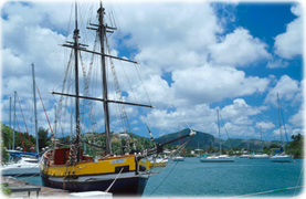
Nelsons Dockyard, in Antigua (photo: High Commission for Antigua and Barbuda).


|
Copyright © Geographic Guide - Travel American Continent, Caribbean Sea. |
Map of Antigua and Barbuda