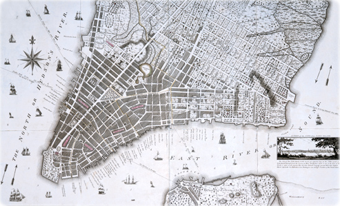
Taylor-Roberts Plan, City of New York - 1796
Original title: A New & Accurate Plan of the City of New York in the State of New York in North America. Year depicted: 1796, published in 1797. It is better known as the Taylor-Roberts Plan. Author: Benjamin Taylor, a surveyor in New York City at the time. Engraved by John Roberts (1768-1803). It shows wards (names highlighted in pink), streets, vegetation, wharves, buildings, architectural elevations of important buildings and ferry routes with distances. Relief shown by hachures and depths shown by soundings. Source: Beinecke Rare Book & Manuscript Library, Yale University. Below, a fragment of the map.
This is one of two large-scale maps of the city published after the Independence War (1775-1783). It includes an inset with view of the city from Long Island.
According to I.N.P. Stokes (The Iconography of Manhattan Island, ... 1915) it is «One of the most accurate and beautiful engraved plans of the city, and particularly interesting on account of its tiny bird’s-eye views of some of the most important buildings, as well as for the clear idea which it gives of the country estates lying along the East River in the vicinity of Crown Point.»
The Taylor-Roberts Plan, 1796 (click on image to enlarge, 23MB). Source: Yale University Library.
|
Copyright © Geographic Guide - Old NYC. Maps 18th Century. |
Taylor-Roberts Plan, City of New York - 1796
