New York in the 18th Century
In the beginning of the 18th century, New York was an English colony. After 1707, it became a colony of the Great Britain. The City of New York had near 1,000 buildings and it was then a major slave market and a supply port for pirates and merchants. An extensive wharf for building ships was developed at the East River waterfront.
The New-York Gazette, the first New York newspaper appeared on November 8, 1725, and local newspapers led to a growing spirit of independence.
From 1744 to 1748 there was King George’s War. Fear of French and Indian invasions led to the construction of palisades, block houses and four gates in 1745. The palisades crossed Manhattan Island, from the East River to the North River, across the Common. They were removed in the 1760s.
The City was a base for British operations in the French and Indian War, from 1754 to 1763. In 1760, the City of New York had 18,000 inhabitants and it surpassed Boston to become the second-largest city of the British colonies.
The Stamp Act passed by Parliament on 22 March 1765 with an effective date of November 1st. In protest, New York hosted the Stamp Act Congress in October, consisting of representatives from British colonies in North America. A mob was organized by the Sons of Liberty and, on November 1st, the Governor’s carriage was burned, the house of Royal Artillery Major Thomas James, at Vauxhall, was ransacked and his possessions burned, in addition to other acts of protest that took place in the City. Parliament voted to repeal the Stamp Act on March 18, 1766 and a Liberty Pole was erected in the Fields (now City Hall Park) to celebrate the event.
The War of Independence started in 1775. The City of New York was of strategic importance and George Washington established its headquarters at Bowling Green, in April 1776.
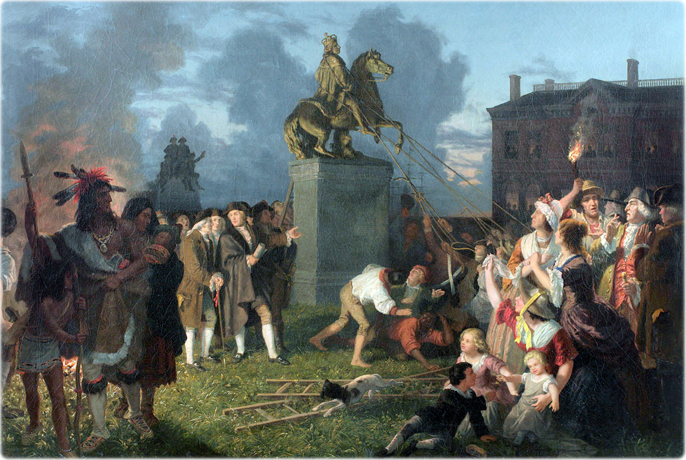
Called to Philadelphia to confer with the Continental Congress about military matters, Washington left New York on 21 May. Having finished his official business in Philadelphia, G.W. received permission from Congress, on 3 June, to return to his headquarters. The next day he began his journey back to New York, where he arrived on 6 June. On July 9th, Washington had the Declaration of Independence read to his troops and the citizens of New York. The City then had about 25,000 inhabitants.
In September 1776, the British invaded New York and the City was burned a few days later. On 25th of November, 1783, New York was evacuated by the British. Washington with its remaining army and Governor Clinton with civil officers of the State marched in to take possession.
After the War, New York was established as the capital of the United States of America. The Constitution was ratified in 1788 and the City Hall was remodeled for the new Federal Hall. On April 30, 1789, George Washington was inaugurated as the first President of the U.S.A. at the Federal Hall. In 1790, the national capital was transferred to Philadelphia, but the City of New York kept its momentum.
In 1794, many street names and its numbers were changed. For example, Great George Street and Broadway, became Broadway; Copsie Street became State Street; Golden Hill and John streets became John Street; Crown Street became Liberty Street, Little Queen Street became Cedar Street; King Street became Pine Street; Pearl Street, Great Dock Street, Hanover Square, and Queen Street, became Pearl Street, etc.
In 1797, the state capital was moved permanently to Albany. The Government House, facing Bowling Green, became a tavern and housed the Custom House in 1799.
In 1800, with 60 thousand inhabitants, New York was the largest city of the United States.
More: Maps of NYC - 18th Century ►

Pulling Down the Statue of King George III, New York City, by Johannes Adam Simon Oertel. This gilded lead statue was placed on Bowling Green and was pulled down by the New Yorkers and Continental soldiery after the Declaration of Independence had been read by George Washington on July 9, 1776. On the right is the Kennedy Mansion on the site of the Washington Building. Source: New-York Historical Society.
|
Copyright © Geographic Guide - NYC in 18th Century. |
New York in the 18th Century
