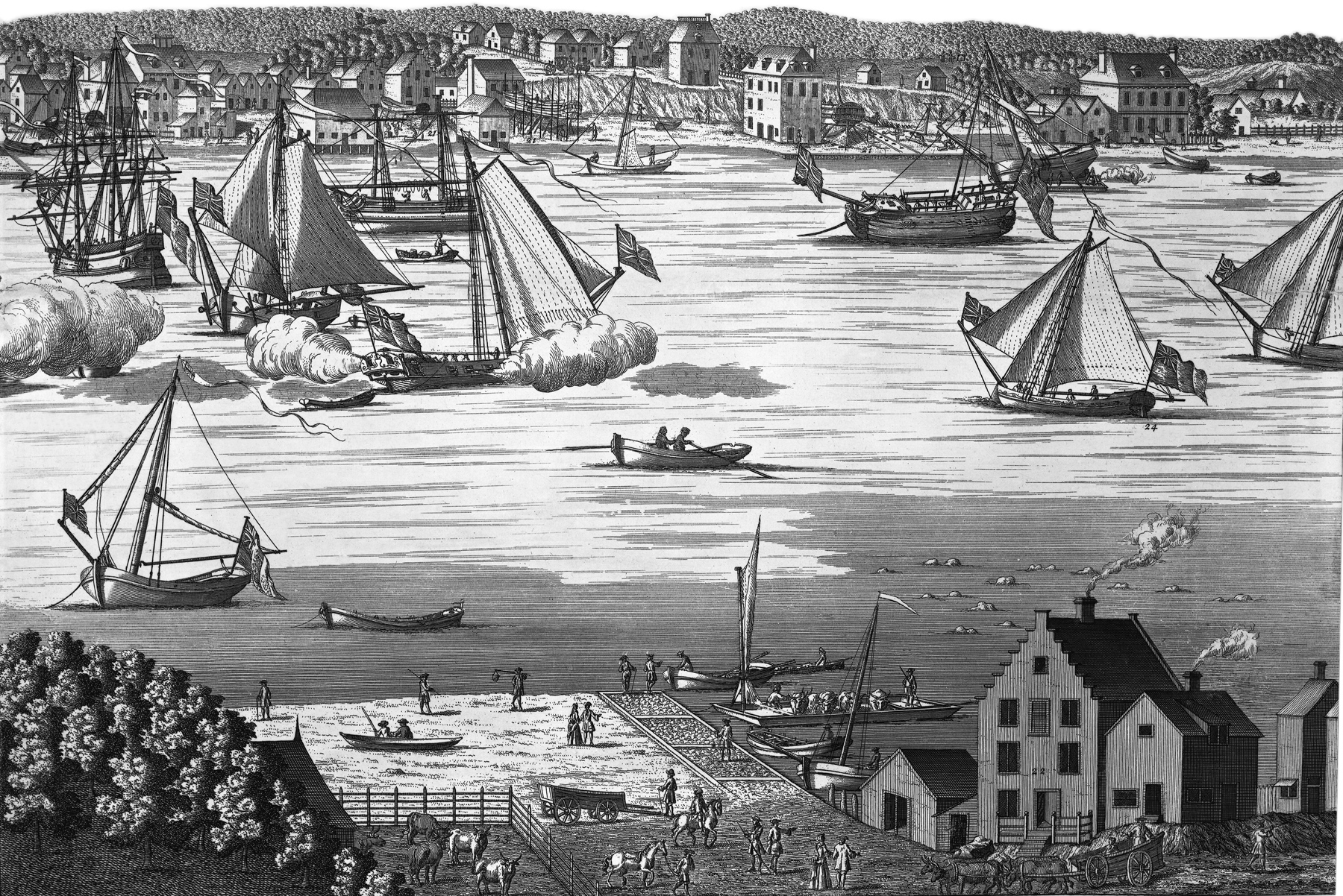
South Prospect, City of New York
This is the fourth of the four plates of the original Burgis View of New York City, depicted between 1716 and 1718 by William Burgis, from Brooklyn Heights. Original title: A South Prospect of ye Flourishing City of New York in the Province of New York in America. Source: New York Public Library.
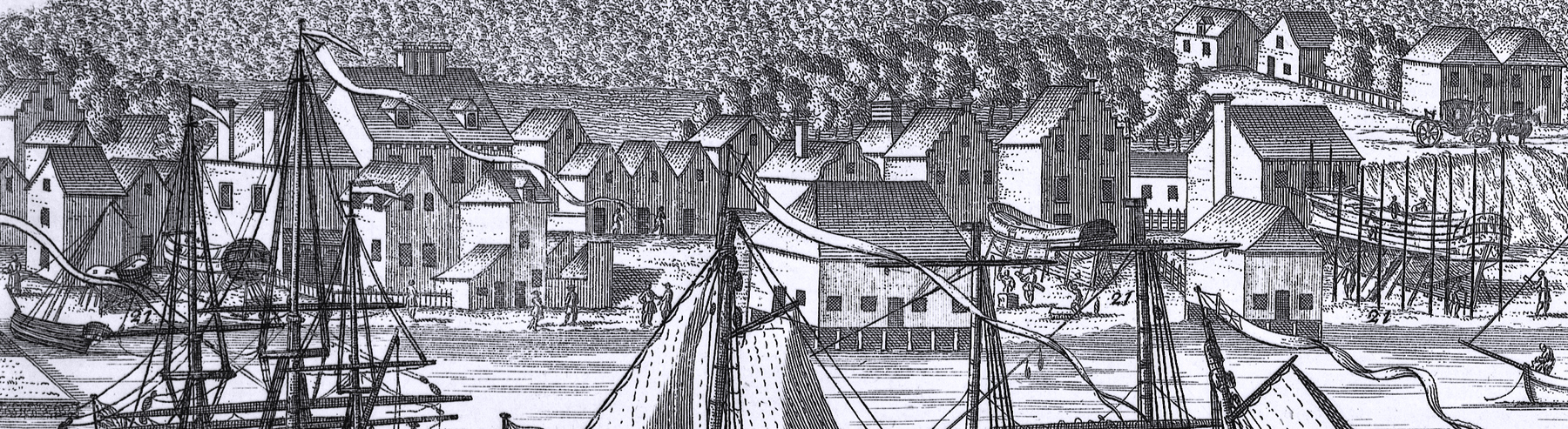
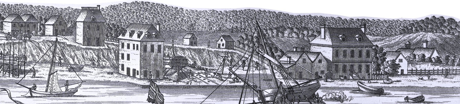
This plate 4 shows the wharfs for building ships in Manhattan and part of Long Island (now Brooklyn). Enlargements of the Manhattan buildings are below. Reference numbers included in this engraving, with comments from Stokes (Iconography of Manhattan Island, ... 1915):
"21 - Warfs for Building Ships."
"22. The Ferry House on Long Island side." This ferry was established some time prior to 1643, in which year Cornelis Dircksen (Hoochlandt) sold his house and garden with some sixteen or seventeen morgens of land on Long Island to William Tomassen, together with his right of ferriage. That a tavern existed here as early as 1650 is shown by a statement in Van Tienhoven’s reply to the Remonstrance, under date of November 29, 1650, that the taverns at the ferry and at Flushing were the only ones in the neighboring towns. Prior to 1654 the ferry was operated without particular oversight by the government of New York. In consequence, various abuses had arisen. People wishing to cross the ferry were sometimes obliged ‘‘to wait whole days and nights,” and sometimes ‘‘to give up their journey not without gross extortion of double and higher fare, disputes and other unmannerly practices.” To remedy these abuses, the Director-General and Council ordained, July 1, 1654, that thenceforth no one but the authorized lessee of the ferry should carry passengers or cattle. Fees were regulated, and the ferryman was ordered to have a sufficient number of boats with men to operate them. He was to be on duty in the summer from five in the morning until eight o’clock at night, and in the winter from seven until five, although he was not bound “except he please, to convey anyone over in a tempest, or when the Windmill hath lowered its sail in consequence of storm or otherwise.” The ferryman was compelled, also, to maintain a “covered Shed or Lodge” on both sides of the river to shelter passengers. In the following year (1655) the first ferry-house was built on the Brooklyn side. The ferry was at this time operated by Egbert van Borsum, to whom the property had been conveyed in 1653 as ‘‘a house and lot by Wolpherts valley now called The Ferry.” [This conveyance refers to the Ferry Terminus on the New York side]. In 1661, Van Borsum was succeeded as ferryman by Albert James van Heemst, and he, some time before October 23, 1663, by Pieter Lucasen. The ferry was farmed out at “Publick Out Cry,” and was operated later by different ferrymen. In February, 1699, various regulations for the ferry were prescribed by the Common Council, among them being the maintenance of two large boats for carrying cattle and two small ones for passengers, and a pound for cattle to be transported to New York. The Common Council also resolved, at this time, to erect “A good sufficient house of Stone and brick two Stories High,” the old ferry-house being “Soe far gone to decay” as to be past repairing. In this new ferry-house, the lessee of the ferry was ordered to keep a “publick house of Entertainment”’ where men and horses might have ‘‘good Accomodation att Reasonable Rates.”. This house had been completed by December 27, 1700, when the ferry “with the New Brick house Barne and Pen thereunto belonging” was farmed out to Dirck Benson. At the time of our view, James Harding was the ferryman.
"23. Pen for Oxen and Cattel designed for the Markett." [Long Island] One of the conditions of the lease of the ferry to Dirck Benson, in 1700, was that he should keep a pen or pound for cattle, etc.
"24. Collonel Morris’s Fancy turning to Windward with a sloop of Common Mould." This is probably the first view showing an American yacht—the noted “Fancy” belonging to Col. Lewis Morris.
Burgis View: 1716 - 1718, Plate 4.

 From
Rodman's Slip to Beekman's Slip
From
Rodman's Slip to Beekman's Slip
(Foot of Fulton Street)
The ship-yard in the angle (96) belonged to Egbert van Borsum, whose heirs, in 1737, received the water-grant into the East River. The large house on the corner of Pearl Street (97), together with the smaller buildings fronting to the wharf (Water Street) as far as the corner of the slip, all belonged to the Van Cortlandt family. Stephanus Van Cortlandt had a wide water lot here in 1692, and the property remained in the possession of his heirs for the better part of a century. The small buildings between the ship-yard and the Van Cortlandt estate belonged to Joseph Latham. As he was a shipwright, he may also have been the proprietor of this yard. In 1719, he had a controversy with the widow Van Cortlandt about the fence shown in the view.
From Fulton Street to Beekman Street
No. 98 was the slaughter-house of Johannes Beeckman, which had been built subsequent to the order removing the slaughter-houses from Queen Street, near the gate, June 23, 1696 and prior to 1699. It was ordered removed in 1721. The river shore at this point was about midway between Water and Pearl Streets. The land of John Cannon, called Cannon’s Wharf in later days, is numbered 99. The two houses at No. 100 belonged to Gilbert Livingston: one at the corner of Pearl and Beekman; the other at Water and Beekman Streets.
Beyond Livingston’s corner, the view seems to be somewhat inaccurate. There is no doubt that the house on the bluff (101), stood just west of what is now the northwest corner of Roosevelt and Cherry Streets, and that the large house on the shore (102) also stood at the corner of Roosevelt Street, on the river side, at about Water Street. At the time when the view was drawn, these two houses belonged to John Deane. In 1721, the City Slaughter House was established "a little to the westward of the new house of John Deane" (102). A reference to Lyne’s Survey will show the dock of John Deane, the slaughter-house, and the house on the north side of Cherry Street. In 1742, the Deane houses came into the possession of Joseph Latham, from the Deane heirs. A picture of the old Deane house is given in Valentine’s Manual for 1855, p. 593.
The coach and horses (103) stand just at the intersection of Pearl and Cherry Streets (at that time, Queen and Sackett Streets) and the long fence running to the west was the Leisler boundary, near the present line of Frankfort Street, and parallel to it.
Although there remains no vestige of it in the 1717 view, the land between the Deane houses and the ship being built on the shore to the south, had been, a few years earlier, a famous pleasure-ground, called Sackett’s Orchard or the Cherry Garden. The large ship on the ways, north of No. 101, lies just west of the old ferry point of Egbert van Borsum.
The artist has evidently not allowed sufficient distance between Livingston’s corner at Beekman Street and John Deane’s houses at Roosevelt Street, probably because of the limitations of the copperplate. Cherry Street is distinctly seen curving down to the river shore near the present James Street. The big house on the shore (104) at the corner of Catharine Street, stands on ground once belonging to Captain Thomas Delavall. At the time of the view it was in the possession of Abraham Wendell, whose son, John Wendell, when he sold the tract of seven acres to Anthony Rutgers in 1743, recites that his father had "caused a house to be built and erected", which there is every reason to believe was the house here shown. In 1732, Harmanus Rutgers purchased the land shown at the extreme right of the print. The two small houses under the brow of the hill (105) may be plainly seen on the Ratzer Map.
Pen for Oxen and Cattle
Ferry House
Enlargements of buildings in Manhattan.

Colonel Morris’s Fancy
|
Copyright © Geographic Guide - 18th Century Waterfront NYC. Historic Images. |
South Prospect, City of New York