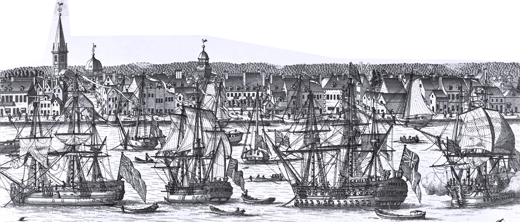
South Prospect, City of New York
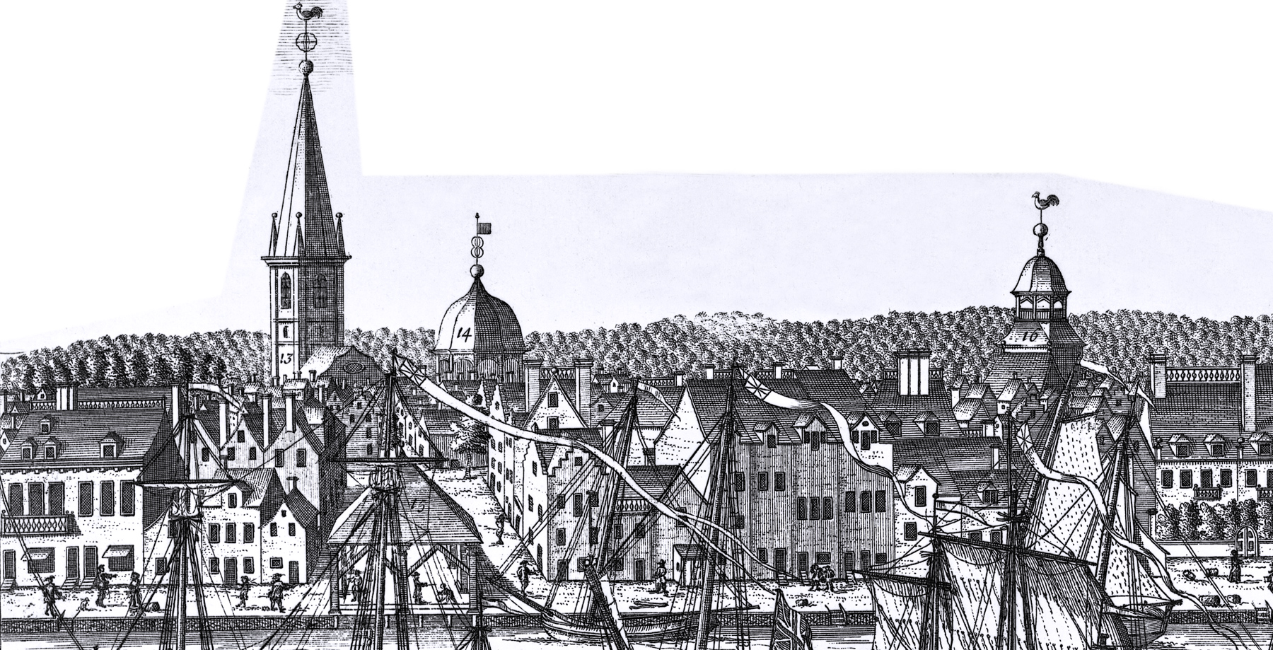
"13 - The English Church." Trinity Church, erected 1696-8; steeple finished in 1711; enlarged in 1724, and again in 1735-7; destroyed in the Great Fire of 1776.
"14. The City Hall." Begun in 1699 on site of present Sub-Treasury; third story added in 1763; remodelled in 1788-9 for the national Congress and called Federal Hall; torn down in 1812.
"15. The Exchange." Established in 1670 by Gov. Lovelace. In 1716, described by John Fontaine as "a small place that is planked and hath pillars of wood all round, which support the roof and leave it open on all sides." Thus shown in our view. In 1752, a new Exchange was erected on the same site.
"16. The French Church [Eglise du St. Esprit, Pine Street].” Erected in 1704 on the north side of Pine Street, east of Nassau. Rebuilt in 1796. In 1834 the property was sold.
"17. Upper Market." Called Fly Market from its location in the Smith’s Vly (Valley) or Smith’s Fly, now Pearl Street and Maiden Lane. Established in 1699, although the building was not erected until nearly seven years later; torn down in 1796; rebuilt in 1797; finally demolished in 1822.
"18. The Station Ship."
"19. From A to A, Warf." [fist A on Plate 2].
"20. The Armes of the Province Supported by Plenty."
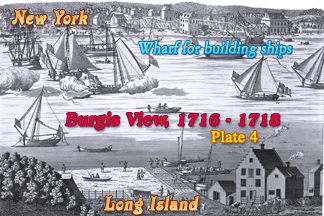
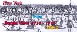
This is the third of the four plates of the original Burgis View of New York City, depicted between 1716 and 1718 by William Burgis, from Brooklyn Heights. Original title: A South Prospect of ye Flourishing City of New York in the Province of New York in America. Source: New York Public Library.
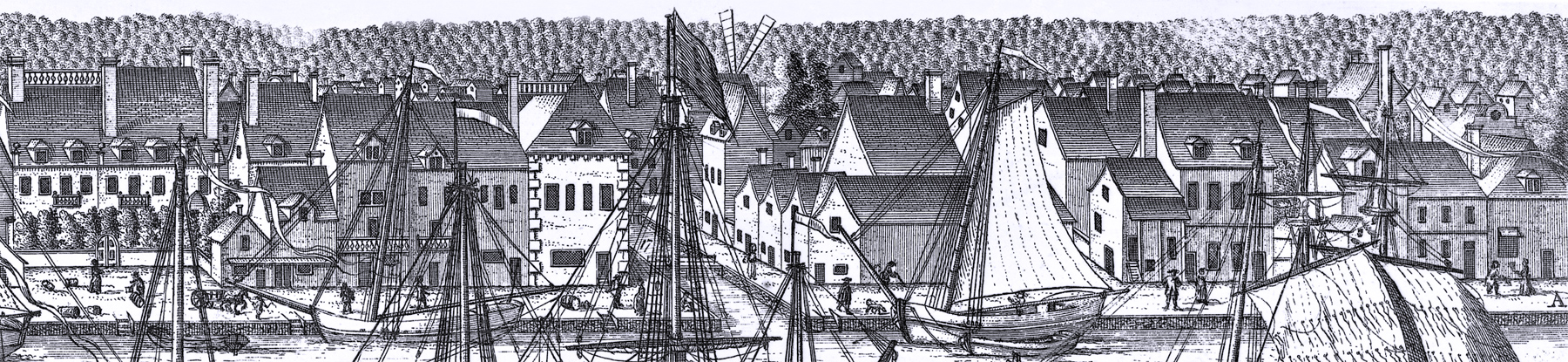
This third plate of the Burgis View shows the wharf from a point south of the foot of Wall Street to its northern end, near the wharfs for building ships. Enlargements of the buildings are shown below. Reference numbers included in this engraving, with comments from Stokes (Iconography of Manhattan Island, ... 1915):
 From
Wall Street to Pine Street
From
Wall Street to Pine Street
The house with the two gables, one on Wall and the other on Water Street (72), is the dwelling of Thomas Clark. It did not stand directly on the corner of Wall and Burnet (Water) Streets, but 27 feet back. This location was always called, in water-grants and conveyances, “Clark’s Corner”. The smaller house (73), which comes out to the wharf, belonged to Thomas Child, whose deed allowed him to “use the south east gable end of Thos. Clark’s dwelling house for a partition wall, one half of which side wall doth stand on the premises sold [to Child]”.
At No. 74 lived heirs of Richard Lawrence, perhaps his daughter Charity, the wife of Samuel Payton, to whom he bequeathed the property in 1712. No. 75 is the “dwelling-house” of Rutgert Waldron, and Nos. 76 and 77 the properties, respectively, of Peter Bresteade, and Isaac D’Riemer. No. 78 was granted to George Heathcote, the founder of the family of that name, through whose extensive patent King (Pine) Street was cut. He was the uncle of the famous Col. Caleb Heathcote, who inherited this property from him. This same plot came afterwards into the possession of the Schuyler and Livingston families.
Joseph Baker, before his death, in 1711, had built three houses on his property (79) ‘‘which three tenements,” as he observes in his will, ‘‘make the corner of King Street.” These houses, which were bequeathed to Baker’s son, William, obscure the corner of King (Pine) Street in the view.
From Pine Street to Maiden Lane
Nos. 80 and 81. These two fine houses fronted on Queen (Pearl) Street at the corner of King (Pine) Street. The view shows their rear elevations, balconies, and gardens. No. 80 was the residence of Garrett Van Horne and No. 81 that of Colonel Abraham de Peyster, and was famous as one of the finest colonial houses of that day. The house was not, however, as will be noted, so extensive as tradition paints it. The large gardens originally belonging to it and adjoining to the east, had, by the period of our view, been covered by the buildings Nos. 82, 83, and 84, which remained the property of Colonel de Peyster. The large double house (85) was undoubtedly that built, c. 1706, by Johannes Kip and Theunis De Key, in common. At the period of the view, Jannetie Tothill, widow of Jeremiah Tothill, owned the westerly part and De Key’s heirs that to the east. The corner (86) was probably owned at this time by Rip Van Dam. Originally granted to William Merrit by the city (1692), it came to be well known, before 1721, as "Rip Van Dam’s Corner".
From Maiden Lane to Fletcher Street
The low building (87) on the corner of Countess Wharf (Water Street) and Countess Slip (Maiden Lane) belonged to Robert Lurting, Esq., a vestryman of Trinity Church, Treasurer of the City, and later Mayor. The three small buildings on Maiden Lane, north of the corner (88), belonged to Abraham de Peyster, while the two taller houses, numbered 89, and fronting one on Countess Slip and the other on Fletcher Street, were owned by Sampson Benson, who had bought them in 1711 from the eminent merchant Thomas Pearsall. No. 9o is the wind-mill of Pieter Jansen Mesier, near the corner of Cortlandt and Greenwich Streets.
From Fletcher Street to Rodman's Slip (Foot of John Street)
Abraham de Peyster was the owner of No. 91. The large building, No. 92, and the smaller ones adjoining, belonged to the Schuyler family, whose ancestor, Captain Brandt Schuyler, had received the water-grant in 1692. Nos. 93 and 94 were, respectively, the property of Dr. John Rodman and William Huddleston. No. 95, at the period of the view, belonged to Matthew Benson, who had purchased it from Dr. Rodman and another of his partners, Thomas Stevenson. Because of Rodman’s extensive holdings at the corner, the slip later became known as Rodman’s Slip (now Burling Slip).
Station Ship
French Church
Trinity Church
City Hall
|
Copyright © Geographic Guide - 18th Century Waterfront NYC. Historic Images. |

Burgis View: 1716 - 1718, Plate 3.
Upper Market
South Prospect, City of New York