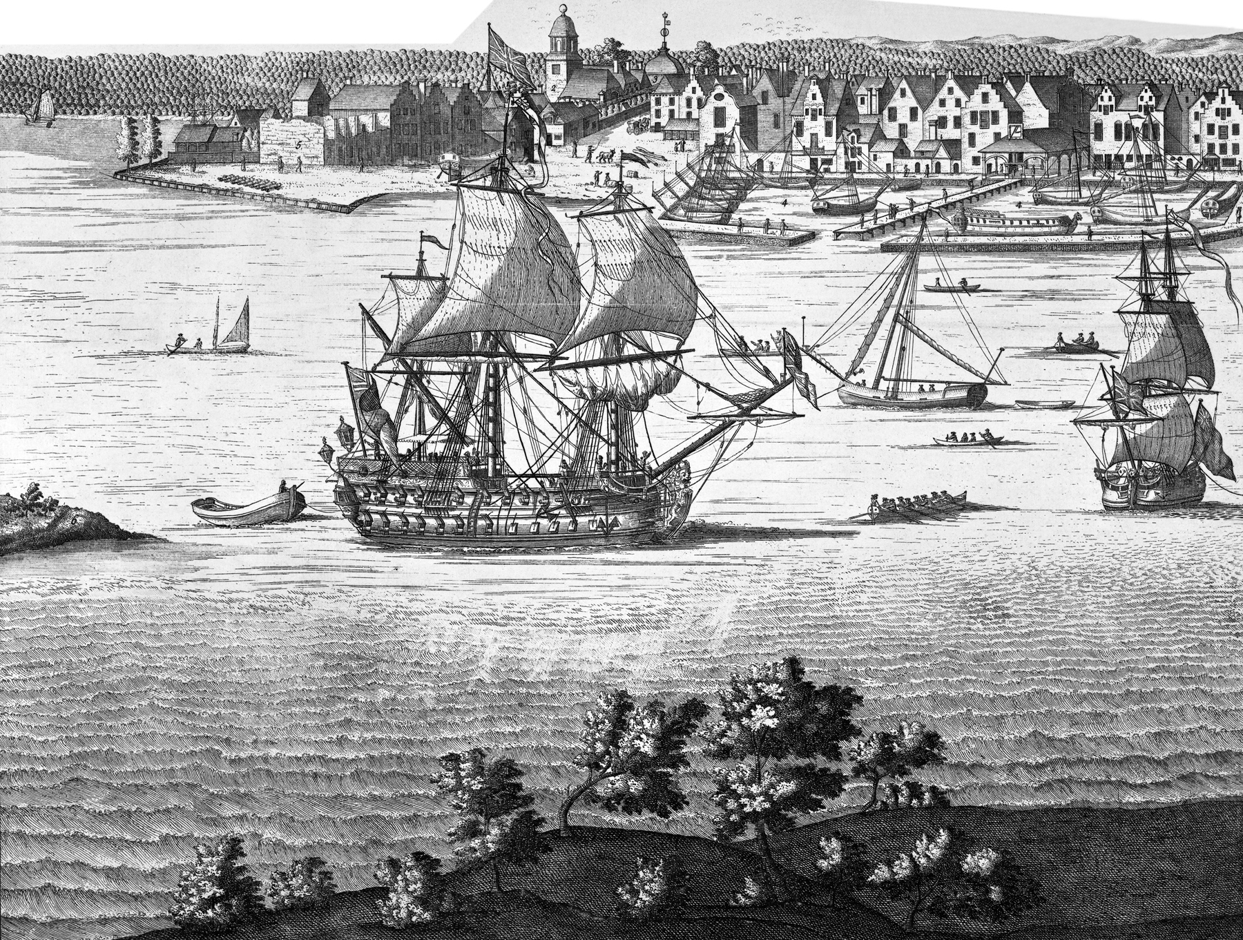
South Prospect, City of New York
This is the first of the four plates of the original Burgis View of New York City, depicted between 1716 and 1718 by William Burgis, from Brooklyn Heights. Original title: A South Prospect of ye Flourishing City of New York in the Province of New York in America. Source: New York Public Library.
This plate shows the southern tip of Manhattan from the turn in State Street west of Whitehall (left), the Great Dock, on the right, and vessels on the East River. Enlargements of the buildings are shown below.
Reference numbers included in this engraving, with comments from Stokes (Iconography of Manhattan Island, ... 1915):
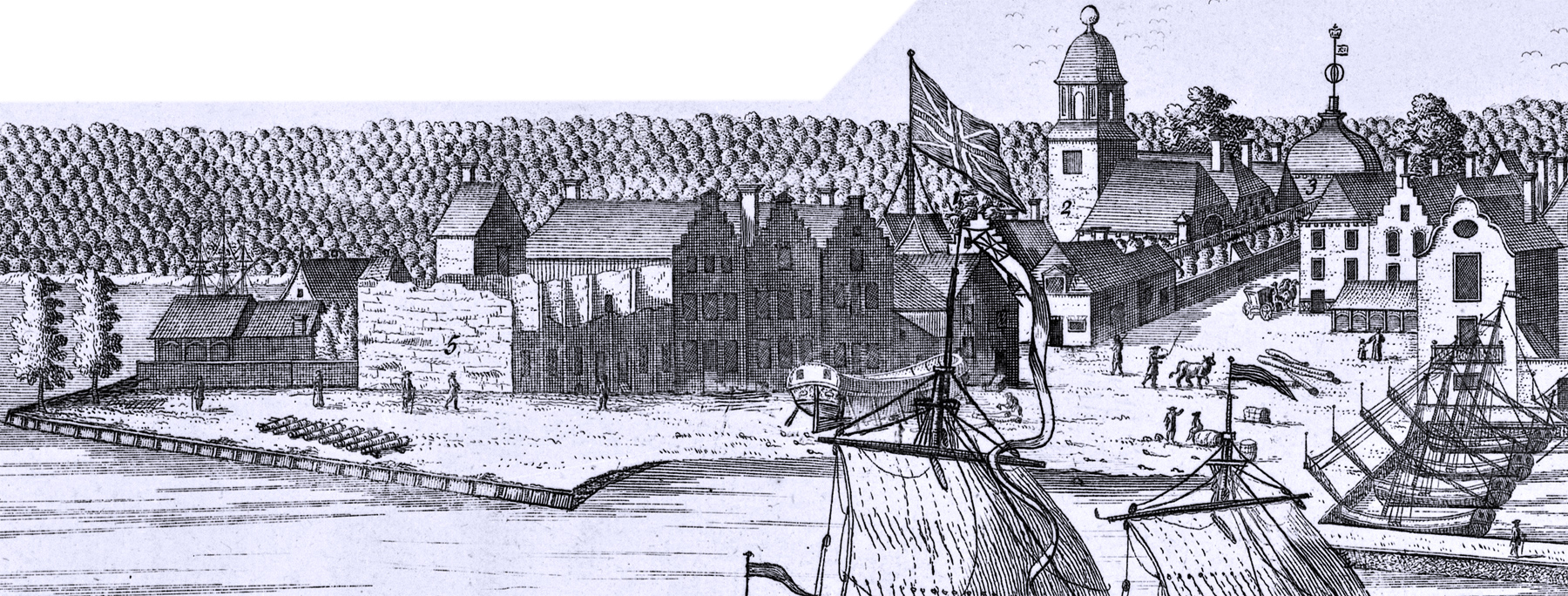
"1 - The Fort" (Fort George). Begun as Fort Amsterdam in 1626 or possibly earlier; rebuilt in 1628 and completed in 1635; many times repaired and strengthened; finally demolished in 1790. John Fontaine, who came to New York in 1716, refers thus to the Fort: "Oct. 27th. About nine I went and breakfasted at the Coffee-House, and at eleven I waited upon Governor Hunter, who received me very kindly, and invited me to dine with him. After dinner I walked with him about the fort, wherein he lives. It is a small square situated upon a height above the town, and commanding it. The one side of it fronts the harbour, and hath a small curtain and two bastions; the land side hath but two half-bastions to it, so that it is a square composed of two whole and two half-bastions. There is a ravelin towards the land that lies on one side of the gate. It is but a weak place, and badly contrived..."
Continue below...
"2. The Chappel in the Fort." Built in 1642; demolished in 1693; rebuilt, under Fletcher, in 1693-6. This is the first view to show the new church as rebuilt at this period. It was destroyed by fire in 1741. Compare this view with its delineation on the Carwitham View.
"3. The Secretaries Office." Erected prior to 1658, as it is mentioned in January of that year in a proceeding of the city court. The building stood inside the Fort to the west of the gate, in which position it is shown, although not named, on the Castello Plan. It was destroyed in the fire of 1741 and rebuilt outside the Fort.
"4. The Great Dock with a bridge over it." The “Bridge” (later the Custom House Bridge), also called the “‘pier”, was constructed in 1659 at the foot of the present Moore Street, and was lengthened in 1660-1. In the latter year a basin or harbour was formed to the west of the Bridge by the construction of a pier running east from the extremity of the filled-in land in front of Stuyvesant’s house at Whitehall. In 1676 the Great Dock was completed by the extension of the last-mentioned pier and the construction of a new pier running out from the Half-Moon Battery in front of the City Hall.
Continue below...
Burgis View: 1716 - 1718, Plate 1.
 Whitehall Street
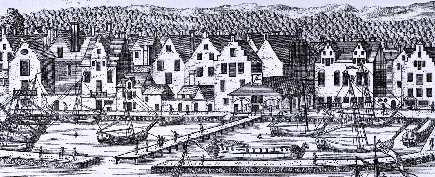
Jacob Leisler, who, with his son-in-law, Milbourne, was hanged for treason in 1691, had owned the two houses, Nos. 25 and 26. Mary Gouverneur, the widow of Milbourne, sold the premises in 1747 to Myndert Schuyler and Adam Dobbs. At No. 27 lived the heirs of the merchant, Daniel Veenvos (Ibid., X XI: 34), and at No. 28 the widow of Christopher Hooghlandt. The north-west corner of Pearl and Whitehall Streets (29) was the property of William Teller at the period of the view. Next westerly was the house where Domine William van Nieuwenhuysen had dwelt until his death (30). The two houses on the north-east corner of the same streets (31 and 32) were at this time, respectively, in the possession of Stephen and Paul Richard.
 from whitehall Street to Broad Street
33. This broad plaza, which was known at the time of our view as Whitehall, later called Whitehall Street, was in 1731-1732, diminished in width by the laying out of the block bounded by the present Whitehall, Pearl, Moore, and Water Streets.
As to the houses facing the Great Dock on Water Street as far as Broad Street, where the Exchange (15) stands, No. 34 belonged to one John Ellison, a “joyner”, and the building in the rear (35) was the warehouse of Col. Abraham de Peyster. The vacant ground to the east (36) was the property of Isaac de Peyster. No. 37, the large house with a high stepped dormer belonged to Thomas Roberts. Johannah Jamieson, the granddaughter of John Hendrix de Bruyn, lived at No. 38, the property having been devised to her by her grandfather in 1709. The next two houses (39 and 40) belonged, respectively, to Thomas Roberts and William Boyle, and fronted on Queen Street. Nos. 41 and 42 were the property of Captain Cornelius de Peyster. The house with the stepped gables was his dwelling-house, erected in 1699, as he says, “to be ye ornament of ye sayde Citty.”
from broad street to coenties slip
 No. 43 was the property of Philip Van Cortlandt and remained
in this family until 1762. No. 44 belonged to Philip French, who had married Annetje, the
daughter of Frederick Phillips (will of Frederick Phillips, dated October 26,
1700). The large house, No. 45, was devised by the will of Frederick Phillips to
his son Adolphus, to whom he left “five houses and a warehouse in New York
City”. Jacobus Van Cortlandt was the owner of No. 46, and held a
patent, dated 1703, for all the land between Adolph Phillips and Coenties Slip.
No. 43 was the property of Philip Van Cortlandt and remained
in this family until 1762. No. 44 belonged to Philip French, who had married Annetje, the
daughter of Frederick Phillips (will of Frederick Phillips, dated October 26,
1700). The large house, No. 45, was devised by the will of Frederick Phillips to
his son Adolphus, to whom he left “five houses and a warehouse in New York
City”. Jacobus Van Cortlandt was the owner of No. 46, and held a
patent, dated 1703, for all the land between Adolph Phillips and Coenties Slip.
Nutten Island, now Governors Island
"5. The Ruines of White Hall built by Governour Duncan" [Dongan]. Erected prior to 1658 by Stuyvesant. The ruins were still standing in 1769.
"6. Part of Nutten Island." —Governors Island.
"7. Part of Long Island." [now Brooklyn].
South Prospect, City of New York
East River
|
Copyright © Geographic Guide - 18th Century Waterfront NYC. Historic Images. |
Enlargements of buildings in Manhattan.