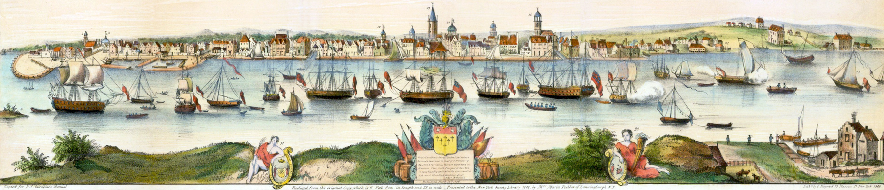
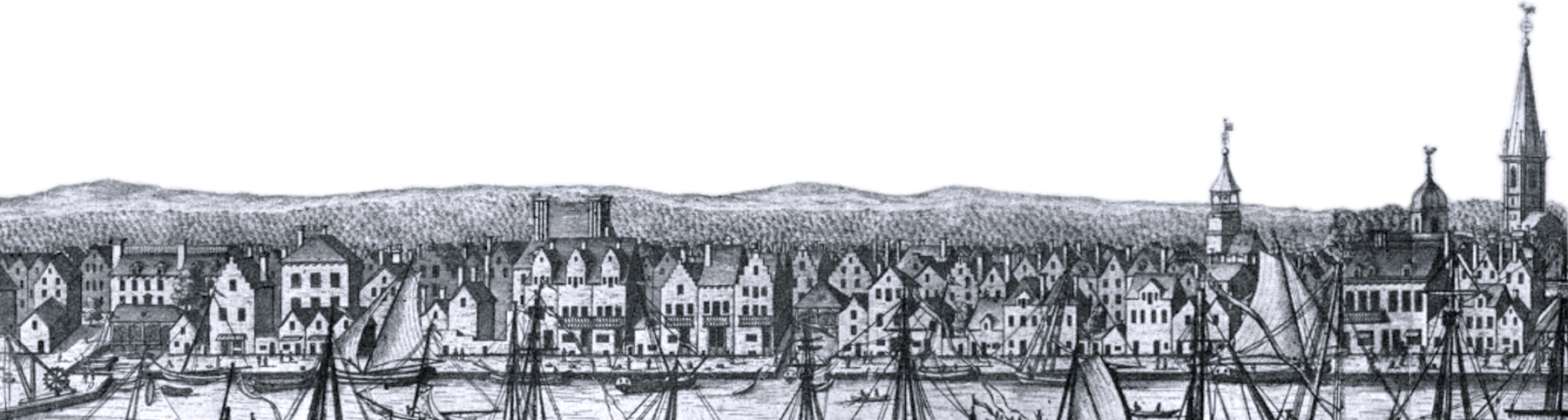
South Prospect, City of New York, 1717 - 1746
Title: A South Prospect of ye Flourishing City of New-York in the Province of New York, North America (Bakewell's original reissue uses only "America" instead of "North America" in the title). Date depicted: 1717-1746. Hand-color illustration engraved by G. Hayward, published in the D.T. Valentine's Manual 1849 (presented to the New York Society Library 1848). Source: Barry Lawrence Ruderman Antique Maps Inc.
The original engraving, known as the Burgis View, was drawn in 1716-1718 by William Burgis, published in 1719-1721, and reissued with modifications on March 25, 1746 by Thomas Bakewell, who had purchased the plates after engraver John Harris' death in 1739. Bakewell added a few buildings, a new dedication and published the engraving under his own name.
Below, reference numbers included in this engraving and enlargements of the buildings in Manhattan in the Bakewell reissue of 1746, reproduced from Stokes (Iconography of Manhattan Island, ... 1915), together with his comments on the engraving.
Burgis View, Bakewell reissue of 1746.
Here, Stokes' comments on the engraving (Iconography of Manhattan Island, ... 1915):
«The Arms are changed and the dedication reads: ‘‘To His Excellency George Clinton Esqr. Captain General,” etc., instead of “To His Excellency Robert Hunter Esqr Captain General,” etc. The date in the Province Seal is altered from 1717 to 1747, although the seal itself is still that granted by George I in 1718. “W. Burgis Delint” etc., is erased, but “I. Harris fec.” is left below the lower right-hand corner of the view above the legend.
The Whitehall Battery at the southern point of the Island, erected in 1734-41 (...), has been added, and also the Lutheran Church on the west side of Broadway below Trinity, built in 1727-9 (...), and the New Dutch Church on Nassau Street between Cedar and Liberty Streets, finished in 1731. Although the Church in the Fort and the Secretary’s Office were burned in 1741, they still appear in the 1746 view. A comparison of the tower of the Lutheran Church, as here shown, with its representation in the Carwitham View (...), in David Grim’s reproduction (...), and in the Banyer painting (...), shows that this church has been drawn without an accurate knowledge of its architecture. The same may be said of the New Dutch Church, the most northerly of the group of churches shown in the view. Indeed, this church is quite erroneously drawn, as may be seen by comparing it with the Rip Van Dam View (...) or with its delineation about ten years later in the Banyer painting. It will be noticed that the tower is shown on the south end instead of on the north as it should be.
It seems quite evident that Bakewell, wishing to bring the Burgis plate up to date, and not having authentic information at hand, made these changes largely from his own imagination. A minute comparison of the French Church as here shown with its representation in the Burgis View reveals the fact that it has been redrawn together with the small buildings immediately in front of it. In the original, traces of the change may clearly be seen with a glass. In redrawing this church the artist slightly altered the point of view, placing himself a little farther to the north, at the same time leaving out the reference number 16. It is hard to assign a reason for these changes. Although this reissue bears the date of publication ‘‘1746,” attention has already been drawn to the fact that the seal of George I has not been altered. The reversed date in its lower border has, however, been changed from 1717 to 1747 (not 1746).
From the fact that the first part of the publisher’s imprint, “London Printed and sold by Tho. Bakewell, Map and Print Seller against Birchin Lane in Cornhill” centres under the escutcheon and inscription of dedication, it seems likely that the remainder, “where Merchants and others may be supplied with all sorts of Maps, Prints & Pictures at the lowest prices,” was a later addition, which fact would make this perhaps the third issue from the plate.
The first appearance of Thos. Bakewell in the London directories is in Osborn’s fourth edition, of 1749, in which his address is given simply “Cornhill,” without any designation of his trade. Mr. Soulsby, of the South Kensington Branch of the British Museum, has, however, a slip reference to an undated map of Berkshire, about 1730, with the imprint of "Tho. Bakewell next ye Horn Tavern in Fleet St. London," the same imprint which appears on the Bakewell reissue of the Burgis View. “Against Birchin Lane in Cornhill” appears too, in "A new and accurate Map of Scotland," by Bakewell, also dated 1746, and preserved in the British Museum. There are doubtless many other maps and views bearing Bakewell’s name in the British Museum, but as the publishers are not separately indexed in the Catalogue, it is quite impossible, in a collection of many thousands of prints, to find them except by chance.
It may be interesting here to review the results of an examination of the London directories (first published in 1738), made for the author by Mr. Henry N. Stevens to establish the sequence of an important group of closely related publishers whose imprints appear on American views of the eighteenth century. In 1749, Bakewell’s name first appears in Osborn’s Directory, with address simply Cornhill and without any trade designation. In the same year, John Bowles first appears, with the same address. In 1752, Bakewell drops out but John Bowles continues. In 1753, the firm becomes John Bowles & Son, and this form continues down to 1763. In this last year, the firm of Bakewell & Parker, printsellers, Cornhill, first appears. In the directories from 1765 to 1774, the firm known as John Bowles & Son becomes again John Bowles, and for the same years the firm of Bakewell & Parker is superseded by Henry Parker, 82 Cornhill. Carington Bowles first appears in the directory for 1765.
The copy of the Bakewell View in Mr. Pratt’s collection, which is in soft contemporary colouring, lacked practically the entire title, but this has been very skilfully restored in photogravure. The view itself was rather badly water-stained and a number of small pieces were gone, principally, however, from the sky and water, the city itself being intact. The print has been cleaned, rebacked, and very successfully restored by Mr. Hammond Smith of the Metropolitan Museum of Art, who also restored the copy owned by the Society Library. The author’s copy was found mounted on a board, the resin from which had penetrated the paper, rendering it so brittle and dark that its successful restoration seemed almost hopeless. This, however, was finally accomplished with great skill, by Riviere & Son, of London. The print is still in its original hand-moulded frame. There is also in the author’s collection a first section of the print, in contemporary colouring, but with the upper and lower margins trimmed.
A copper-plate reproduction of the Bakewell reissue, 20½ x 6⅛ inches, was published in The London Magazine for August, 1761. Three states of this view are known.
At the right and left of the title of the Bakewell View is engraved an interesting legend of the discovery of the colony and of its early history.
Valentine’s Manual for 1849 contains a lithographic fac-simile of the print presented to the N. Y. Society Library, in 1848, by Mrs. Maria Peebles, of Lansingburgh, N. Y.»

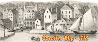
Reference numbers included in this engraving:
1. "The Fort" (first built in 1626 as Fort Amsterdam).
2. "The Chappel in the Fort" (second temple built in 1693-1696, burned in 1741).
3. "The Secretaries Office" (built prior to 1658 inside the fort, burned in 1741).
4. "The Great Dock with a bridge over it" (built in 1659 at the bottom of present Moore Street).
5. "The Ruines of White Hall built by Governour Duncan" [Dongan].
6. "Part of Nutten Island". Now Governors Island.
7. "Part of Long Island" (now Brooklyn).
8. "The Lower Market", established at Coenties Slip in 1691.
9. "The Crane". Continue below...
12. Old Dutch Church
Lutheran Church (not in the original Burgis View). New temple in 1729, drawn here without an accurate knowledge of the architecture of its tower.
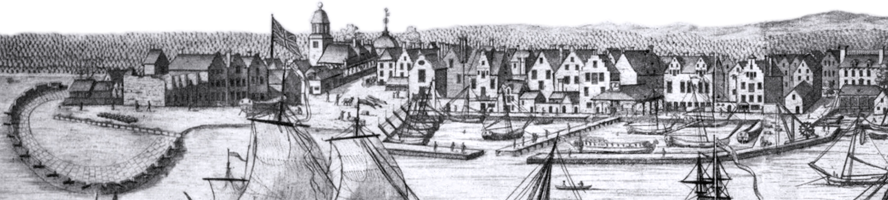
10. "The Great Flesh Market". built about 1701.
11. "The City Armes supported by Peace".
12. "The Dutch Church". Built in 1692-1693, tower added in 1696. After the opening of the New Dutch Church in 1729, the Dutch Church on Garden Street (now Exchange Place) became known as the Old Dutch Church, the Garden Street Church and, after 1769, the South Dutch Church.
13. "The English Church". First temple of Trinity Church. It was enlarged in 1724 and again in 1735-1737, but the design here is the same as shown in the original engraving of 1716-1718. It destroyed in the Great Fire of 1776.
14. "The City Hall" built in 1699 on Wall Street.
15. "The Exchange" established in 1670 on the foot of Wall St.
16. "The French Church" built in 1704 on Pine Street.
17. "Upper Market" established in 1699 on the present Pearl Street and Maiden Lane.
18. "The Station Ship".
19. "From A to A, Warf." Fist A near Coenties Slip.
20. "The Armes of the Province Supported by Plenty".
21. "Warfs for Building Ships".
22. "The Ferry House on Long Island side".
23. "Pen for Oxen and Cattel designed for the Markett", Long Island.
24. "Collonel Morris’s Fancy turning to Windward with a sloop of Common Mould". A yacht on the East River .
1. Fort George
Enlargement of the southern part.
Based on the Burgis View.
13. Trinity Church
2
South Prospect, City of New York, 1717 - 1746
|
Copyright © Geographic Guide - 18th Century Waterfront NYC. Historic Images. |
East River
New Dutch Church, completed in 1731 (not in the original Burgis View). The church is wrongly depicted, with its tower facing south. In the Valentine's Manual edition (top of the page) it is also wrongly indicated as the French Church (16).
5

9
8
16. French Church
3
4
A
15
6
9
14
8
23
A
4
18
22
24
21
21
7