Nassau Street
The historic Nassau Street is situated in the Financial District, in New York City. It begins at the intersection with Broad and Wall streets, with the northern end at Frankfort Street, at Pace Plaza, former Printing House Square. Nassau Street runs one or two blocks east of Broadway (until Ann Street) and Park Row.
Nassau Street was surveyed and laid out in 1689 or before. The street was referred in a deed Dongan to Bayard and De Peyster, May 25, 1689, as a "certain piece of ground in breadth six and twenty foot laid out and surveyed for a street." (The Iconography of Manhattan Island, ..., by I. N. Phelps Stokes, 1915). The street was represented by dashed lines on the John Miller's map, 1695, without a name, extending north beyond the physical wall of Wall Street. The name Nassau Street (for William, Prince of Nassau) appeared in "A Map or Chart of a certain Tract of Land commonly call'd the Shoemakers Land..." surveyed and laid out by James Evetts, city surveyor, dated September 14, 1696 (according to Stokes). The Shoemakers’ Field consisted of about 17 acres of land, bounded westerly by Broadway, southerly by Maiden Lane, and easterly by a fence which separated it from Van der Cliff’s Orchard. This Evetts' chart recorded Nassau Street as the section north of Maiden Lane and Kip's Street (after Jacob Kip, from an early Dutch settler family) as the section south. A map of Wall Street in 1718, shows Kip Street as the beginning of the present Nassau Street, so we can infer that in the late 17th century, the section between Wall St. and Maiden Lane was called Kip Street.
The name appears in the James Lyne's 1730 plan, ending about Ann Street. In the 1742-1744 David Grim's plan, it continues as Kip Street, after Ann St., which seems to be the same in the 1755 Duyckinck Map. Kip Street became "Kid Street" in the Major Holland's 1776 plan. Later maps did not record Kip or Kid Street in that section.
The old Federal Hall blocked Nassau Street from reaching freely Wall Street (see 18th century's NYC maps. Also compare the 1811 and 1833 maps). It was demolished in 1812. The U.S. Custom House (today Federal Hall Memorial National Historic Site) was built on part of the site, from 1834 to 1842, facing Wall, Nassau and Pine streets.
In the 19th century, Nassau Street developed as a business street, with the Post Office (former Middle Dutch Church), several stores and offices, many in the publishing sector. After the Brick Church, at Park Row, Beekman and Nassau streets, was demolished in 1857, the Printing House Square. was formed.
By the late 19th century, many building of this historic street began to be replaced by office skyscrapers.


In the 18th century, the old City Hall stood at the beginning of Nassau Street. Today the site is occupied by the Federal Hall Memorial National Historic Site, former Sub-Treasury.
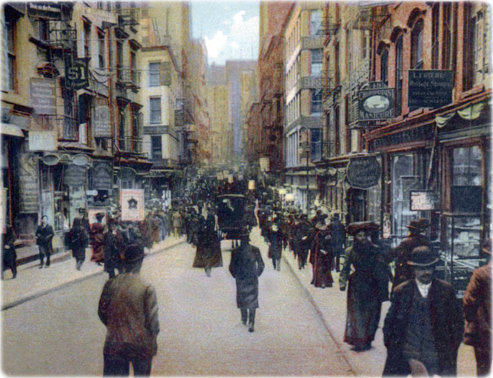
Crowded Nassau Street, north from Liberty Street, about 1905. Postcard by Rotograph Company.
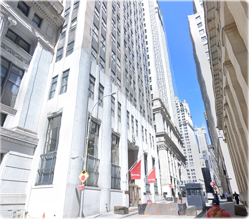
Nassau Street, April 2021, north from near Wall Street (Google Street View).


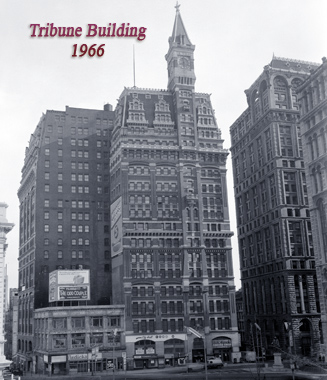
Originally completed in 1875 and expanded later, the historic Tribune Building was located on the corner of Nassau and Spruce streets, facing the Printing House Square.

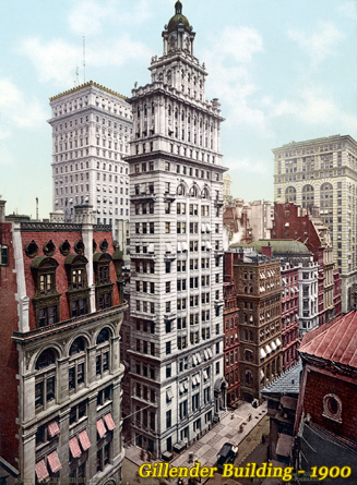
Gillender Building, completed in 1897, northwest corner of Nassau and Wall streets, was one of the early skyscrapers in New York City.

Nassau Street
|
Copyright © Geographic Guide - Old NYC. Historic Places. |