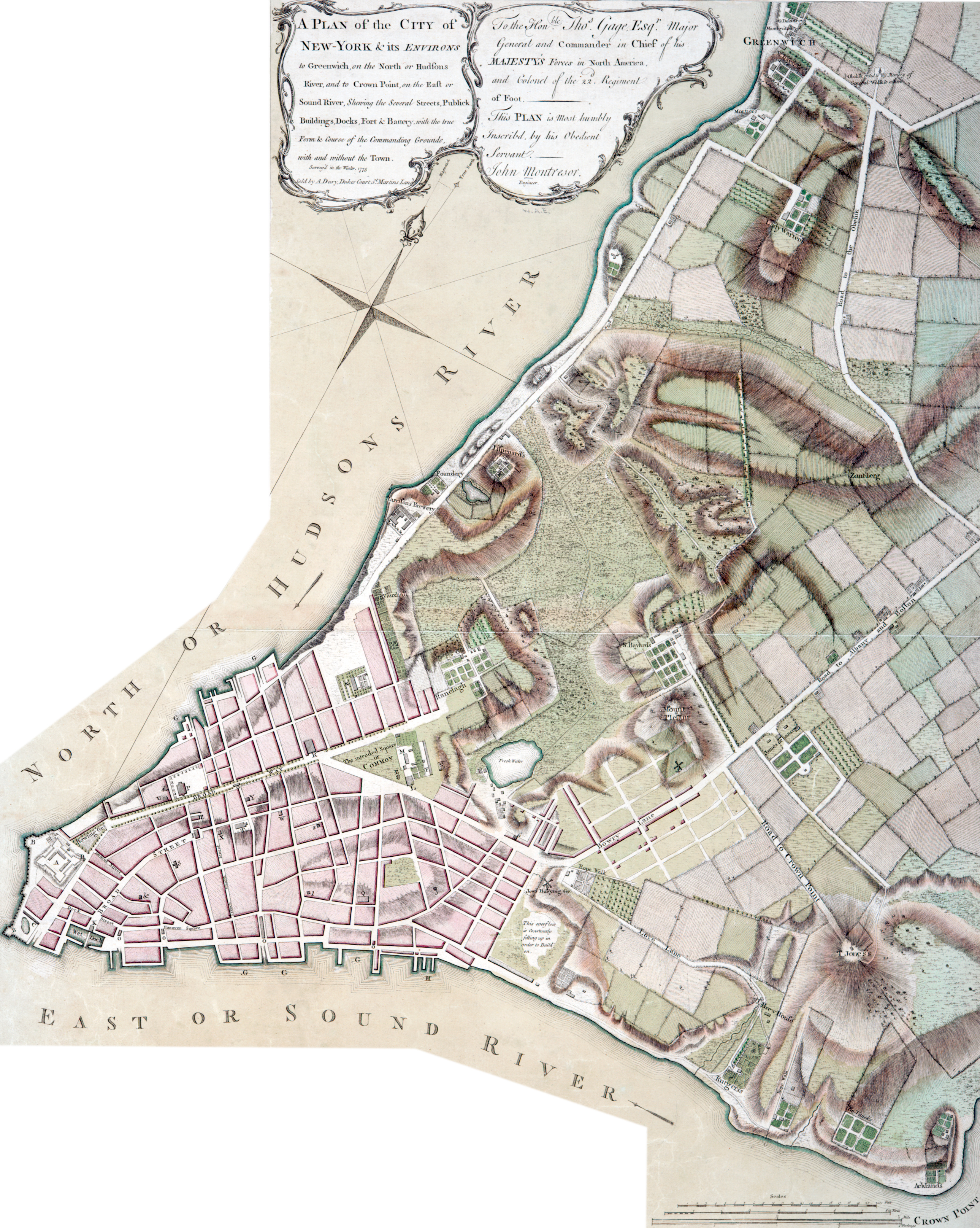
Map of New York City by John Montrésor - 1775
Original title / description: "A Plan of the City of New-York & its Environs: to Greenwich, on the North or Hudsons River, and to Crown Point, on the East or Sound River, shewing the several streets, Publick Buildings, Docks, Fort & Battery, with the true Form & Course of the Commanding Grounds, with and without the Town. Survey'd in the Winter, 1775" [1776].
Additional text on print: "To the Honble. Thos. Gage, Esqr., Major General and Commander in Chief of His Majesty's Forces in North America, and Colonel of the 22d Regiment of Foot. This Plan is most humbly inscribd by his Obedient Servant ― John Montresor. Engineer". Engraved by Peter Andrews. Sold by Andrew Dury, Dukes Court St. Martins Lane, London. It includes inset (on the left): "A chart of the entrance to New York from Sandy Hook, shewing the properest channel for sailing, with ye banks and depths of water". Source: New York Public Library.
Captain John Montresor (1736-1799) was Chief Engineer of the British Army, son of Colonel James Gabriel Montresor, both contributors to the Montresor Journals, printed in 1882.
Note: The Brick Church, at Beekman and Nassau streets, was in operation since 1767, but it is not shown here.

|
Copyright © Geographic Guide - 18th Century Maps, City of New York. |
Additional text on print about New York: "Novum Eboracum, a City in the Province of that name; formerly New Amsterdam, and the Country New Netherlands, or Nova Belgia from having been first settled by the Dutch, though first discovered by Hen. Hudson, an Englishman commissioned by King James, and employed by the E. India Company for finding a Passage through N. America to China, in 1608, who sold his discovery to them. This its Metropolis, is situated in 40.Deg.42.Min.40.Sec.N.Lat and on the South West end of the island, of the same name, 14 miles in length, and about one Mile wide, which comprehends the Liberties or Charter of the City, and was called by its original Natives the Savages, Manhattan's Island, the City is Constructed at the confluence of the North or Hudson's River, leading to Albany, and the East or Sound, which divides Nassau, now Long Island (and by the natives Meitowacks) from the Main, and the direct Navigation for small vessells to the Eastern Provinces; it's about thirty miles from Sandy Hook, the entrance from the Ocean, so through a winding course called the East and West Banks, to the Narrows one Mile across, being formed by Long and Staten Islands, both in this Province, on the S. West end of the City, stands a Fort of Stone, where the Governor resides, constructed by the Dutch in 1615, called Fort Amsterdam, now Fort George, which has often been repaired the whole en Barbette, & whose Exterior Line is 330 Feet, its Flanks which are very Insignificant, are nearly at Right Angles; it contains Barracks for 200 Men & constructed originally for two of the four New York Independent Companies (tho paid by the Crown) it has two Powder Magazines but damp, & no other Casements, & badly supplied with water; in its N. East Front towards the Town is situated a Ravelin or Couvert-Port en-Barbette that rather obstructs its Defense, which are of themselves but bad, this front is Commanded by a Piece of Ground Equal to it at the end of ye Bowling Green, its Original Parade, & formerly in the Jurisdiction of the Fort; this height is 53.0 feet from it, & where its Principal Streets commences called the Broadway, this Fort is constructed on a Small Nole just sufficient for the Work, which has two fronts to the Town & two to ye water, one facing the East and one the north Rivers, ye Battery which carries a respecfull appearance with it (at a distance) is in a very ruinous situation, & was constructed at an Enormous Expence, & seems to have been intended for Profit & Form then Defence, it being entirely exposed to a fire in reverse, & Enfilade; it consists of 91. Embrasures, in which are 71 Pieces of Cannon mounted."
Map of New York City by John Montrésor - 1775
References
A - Fort George.
B - Batteries.
C - Military Hospital.
D - Secretaries Office.
E - Powder Magazine.
F - Soldier's Barracks.
G - Wharfs and Quays.
H - Ship Yards.
I - City Hall.
K - Exchange.
L - Goal.
M - Work-house.
N - College [established by Royal Charter granted in 1754].
O - Markets.
P - Trinity Church.
Q - St. Georges Chapel.
R - St. Paul's Chapel.
S - Old Dutch Church.
T - New Dutch Church.
U - Lutheran Church.
W - Calvinists Church.
X - French Protestant Church.
Y - Quakers Meeting.
Z - Presbyterian Meeting.
& - Jews Synagogue.
1. Baptist Meeting.
2 Moravian Meeting.
3. New Lutheran Meeting.
5. Ruins of Alderman, Romers Battery.
6. Fresh Water Engine from whence the Town is supplied.
