
Dock and Water Streets, New York City - 1772
Original title: Plan of the Ground between Coenties Slip and White-Hall Slip, made by Gerard Bancker City Surveyor - November 10th, 1772. Source: New York Public Library.
It shows piers and wharves in the East River waterfront, Coenties Market, the Exchange, properties in Water Street and Dock St. (now Pearl Street), including the present Fraunces Tavern Block.
|
Copyright © Geographic Guide - 18th Century Maps, Historical Maps, City of New York. |


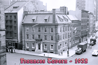

Augustus F. van Cortlandt, Peter Jay, John W. Vredenburgh, Henry Remsen, Henry Holland, Waldron Blaav, William Milner. The latter is the Fraunces Tavern property.

Showing Fraunces Tavern.
Dock and Water Streets, New York City - 1772