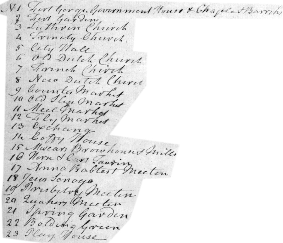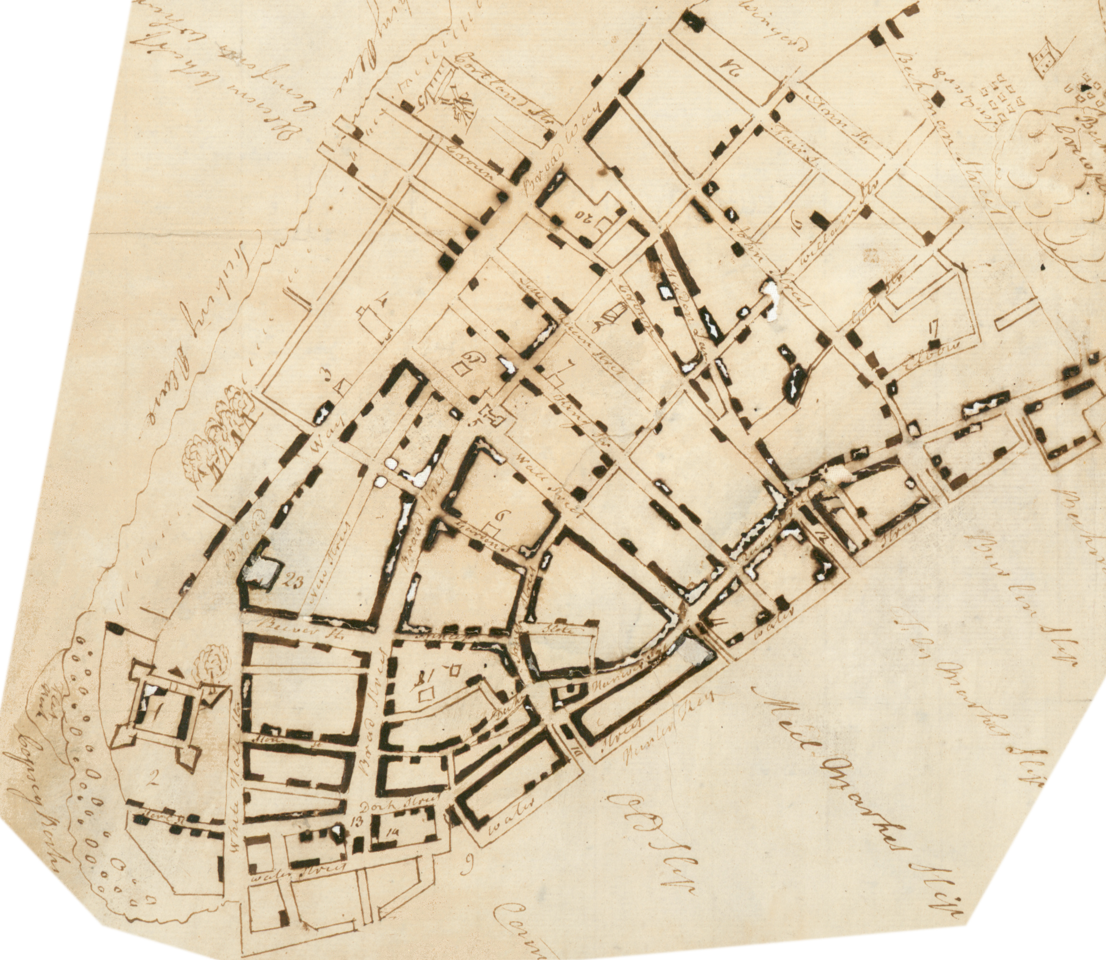
Map City of New York - 1735
Original title: Plan of the City of New York in the Year 1735. Owner: Isaac Newton Phelps Stokes (purchased at the Edwin B. Holden sale). Pen and ink drawing on paper published in the The iconography of Manhattan Island, 1498-1909. Compiled from original sources and illustrated by photo-intaglio reproductions of important maps, plans, views, and documents in public and private collections - Volume I, 1915, by I. N. Phelps Stokes.
Isaac Newton Phelps Stokes (1867-1944) was an architect born in Manhattan. He worked on the Iconography of Manhattan Island, a six-volume compilation, for about 20 years.

Additional information from Stokes (Iconography of Manhattan Island, ...1915):
This manuscript plan contains references to buildings and topographical features not shown on any other known plan of the city. For example, No. 23, “‘Play House.” This is the first plan upon which reference is made to a theatre; although we know that one was in existence as early as December, 1732, for the Boston Gazette of January 1, 1732, contains the following correspondence: ‘‘New York, Dec. 11 [1732], On the 6th Instant the New Theatre in the Buildings of the Honorable Rip Van Dam Esq; was opened, with the Comedy called The Recruiting Officer, the part of Worthy acted by the ingenious Mr. Thomas Heady, Barber and Perugue-maker to his Honour.” Although a careful search through the title records fails to disclose any property on Broadway owned by Rip Van Dam at this period, it seems nevertheless probable that the advertisement quoted above refers to the ‘‘ Play House” here shown, as, in The New-York Weekly Journal of February 2, 1740, we find another advertisement specifically referring to the ‘New Theatre” on Broadway: “On Thursday, Feb. the 12th at the new Theatre in the Broad Way will be presented a Comedy call’d the Beaux Stratagem,” (etc.). Why the above notice is the solitary reference which we find to a theatre on Broadway in any of the New York papers of the period it is not easy to explain, except on the theory that in these early times theatres were not considered altogether reputable, and were not popular with the respectable, newspaper-reading community. At this period, too, the theatre was a transient institution, and plays and concerts were often given in the long-rooms of taverns, the place varying with almost every season. Thus, in 1736, the same play, ‘‘The Recruiting Officer,” was given in a “new theatre” in Dock Street, possibly the long-room of a tavern. Van Denberg’s Garden, to the west of Broadway, almost opposite the Vineyard, referred to on our map as “‘Van Denberger Meadhouse,” was, in 1753, the site of what may have been a pavilion or out-door theatre, as is evidenced by the following advertisement in The New-York Mercury of August 13th of that year: “This is to inform the Publick, That there is just arrived in this City, and to be seen at a new House built for that Purpose, in Mr. Adam Van Denberg’s Garden, This Evening being Monday, the 13th Instant, The Surprizing Performances of the celebrated Anthony Joseph Dugee. . . . ”
 From
early records, we know that Van Dam at this time owned property on the east side
of Nassau Street, between John Street and Maiden Lane, and also on both sides of
Maiden Lane. He also owned the land on the corner of Maiden Lane and Pearl
Street, which is the site referred to by T. Allston Brown in his History of the
New York Stage, as that occupied by the first theatre. Title records do not show
when Van Dam acquired this latter property, but that he did own it as early as
1720 is proved by the following record from the Calendar of Land Papers: “Caveat
of the corporation of New York, against the granting of a patent to Thomas Clark
and others, to gain upon the water between the house of Rip Van Dam, by the end
of Maiden lane, and the corner, by Capt. Thomas Clarke, next the market house,
at the lower end of Wall street.” Another proof of the ownership by the Van Dam
family of this property is found in Vol. LX of Patents (Albany), where, under
date of March 7, 1722, Van Dam and others receive a patent for ground on the
East River under water from Wall Street “to the southeasternmost corner of the
lot of Rip Van Dam, Jr., which joins to the slip that leads from Maiden Lane.”
In 1734, Judith Van Dam, widow of Rip Van Dam, Jr., applied for and obtained a water grant from the City, wherein it is described as “all that certain water-lot . . . being the corner lot on the westermost side of the slip commonly called Maiden Lane Slip or Countess Key Slip, opposite to a certain Messuage or tenement, fronting the street commonly called Queen Street Wharf [Pearl Street] belonging to said Judith Van Dam (the said street commonly called Queen Street Wharf lying between the tenement of said Judith Van Dam and the water-lot hereby to be granted).” There is nothing in this description, which refers to the building as a “‘messuage or tenement,” to indicate that it was ever used as a play-house, or that it was suitable for such use. It stood on the present south-west corner of Maiden Lane and Pearl Street (197 Pearl Street and 104 Maiden Lane).
On the other hand, we know that, in 1750, a theatre was established in a “convenient room” in one of Van Dam’s buildings on Nassau Street (see Chronology), and that on this same site a new theatre was built in 1753. The New-York Gazette; or, the Weekly Post-Boy, for September 17, 1753, states that ‘‘The Company of Comedians, who arrived here the past Summer, having obtained Permission from proper Authority, to act, have built a very fine, large and commodious new Theatre in the Place where the old One stood; and having got it in good Order, design to begin this Evening: As they propose to tarry here but a short Time, we hear they design to perform three Times a Week.” The same paper contains, also, the advertisement of the play, ‘‘’The Conscious Lovers,” including ‘‘A New Occasional Prologue to be spoken by Mr. Rigby,” and “An Epilogue (address’d to the Ladies) by Mrs. Hallam.” The play was announced to begin, as did almost all plays of the period, at 6 o’clock.
Below, enlargement of the original in the New York Public Library and more comments by Stokes about this map.
More: Maps of NYC - 18th Century ►
|
Copyright © Geographic Guide - 18th Century Maps, City of New York. |

Old Bowling Green. Its location was indeed a little further north.
Name in the top left corner of the original map.

Map City of New York - 1735
