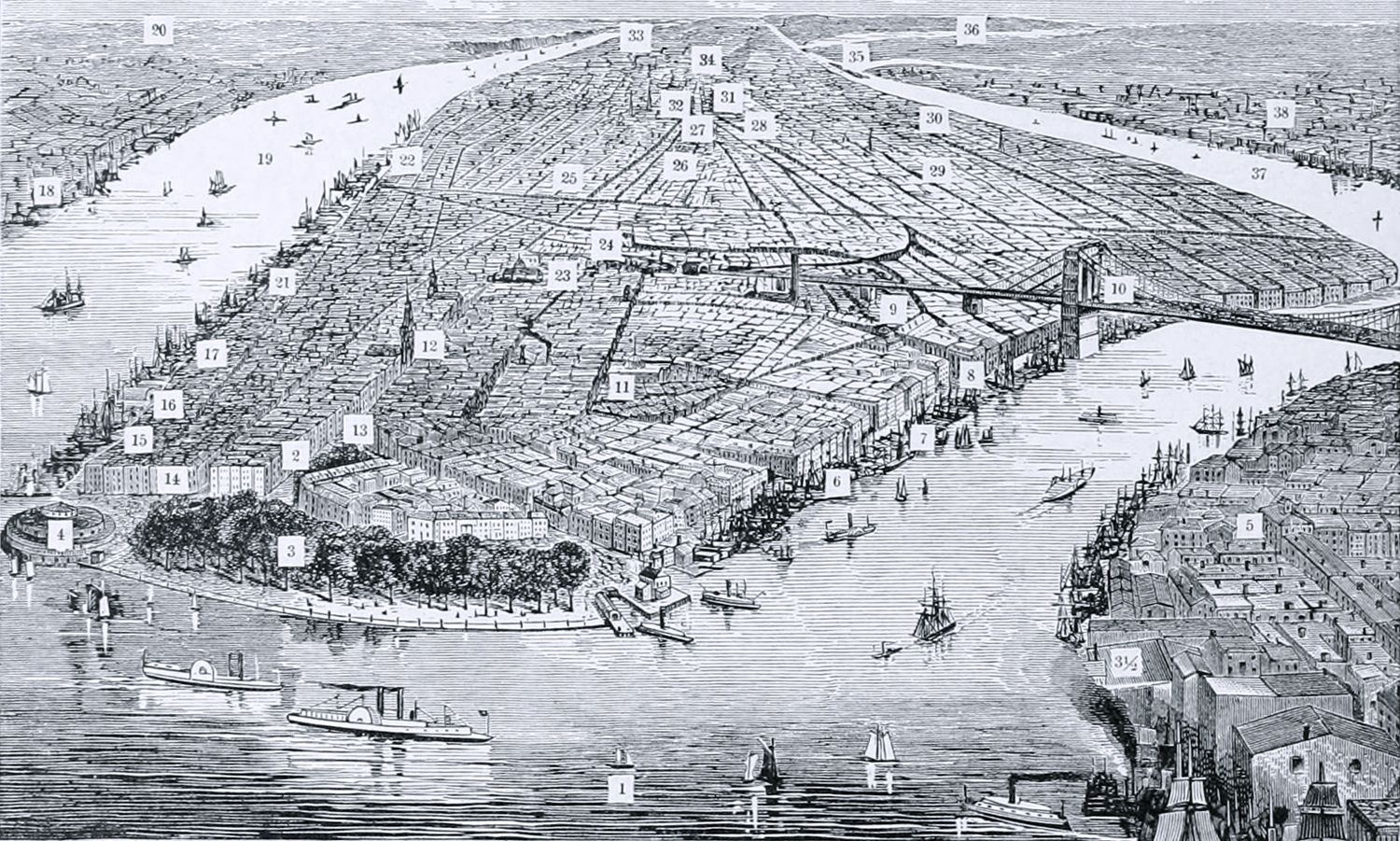
Manhattan, Bird's Eye View - 1881
Wood engraving shows locations of well-known principal places of New York City and New Jersey (on the left), copyright 1881. Cityscape depicted is mainly between the 1860s and 1870s. The Wall Street Ferry, which opened in 1853, is not represented, nor are the early skyscrapers of the 1870s. Brooklyn Bridge was not yet operational. Original title: The Bay and City of New York, Looking Northward. Illustration published in the Hill's Album of Biography and Art... by Thomas Edie Hill (1832-1915), published 1882. Below, text that accompanies the image above:
«New York City is located on the island of Manhattan, a name given it by the Dutch who first located here, in 1614. In 1626 Peter Minuit, a Hollander, bought the entire island from the Indians for sixty guilders, a sum equal to $24. The island was sixteen miles long; was four and a half miles in width at its widest place, and was estimated to contain 26,500 acres.
In 1627 there were about twenty huts on the island, scattered along the East river, and the population was 270 whites. The receipts for furs sent abroad that year amounted to $19,000. One hundred years afterwards the population was 8,622; when two hundred years old it was 93,634, and by the census of 1880 it was 1,206,577.
The Location of Well-known Points of Interest
Are designated by the following numerals, which correspond with the figures in the Engraving.
No. 1. New York Bay, first entered by Henry Hudson in 1609, who then saw and visited the island of Manhattan. 2. The present site of 39 Broadway, where, in 1612, Hendrick Christænsen, a Hollander, first made a small redoubt, enclosing four log huts, as a place in which to live and receive furs. 3. Battery park, at the extreme southern end of the island, containing twenty-one acres, about one mile from City Hall. 3 1-2. Brooklyn Warehouses. 4. Castle Garden, a circular building, where the emigrants land when arriving in New York, a record being made as they pass through of the name of each, place of nativity, age and occupation. 5. Brooklyn; population in 1880, 554,465. 6. Location of the piers for several lines of steamers, which rum to Florida. Cuba, Texas and California. 7. Piers of Hartford and New Haven lines of steamships. 8. Fulton Market. 9. Printing house of Harper Brothers. 10. Brooklyn bridge [opened later in 1883]. 11. Custom house. 12. Trinity church, head of Wall street. 13. Broadway— extending from Battery to Central park, a distance of five miles. 14. Washington House, where Washington made his headquarters while in New York during the revolution. 15. Piers of steamers for New Orleans. 16. Piers of steamers for Boston and points at the south. 17. Piers of the Pennsylvania railroad. 18. Jersey City; population in 1880, 105,000. 19. Hudson river, first discovered by Henry Hudson, an Englishman. September 11, 1609, and navigated by him to Albany, where he arrived September 21, 1609. the journey occupying eleven days. 20. New Jersey. 21. Washington market. 22. Piers from which boats run to the Erie railway. In this vicinity are located also the piers of the White Star line, Anchor. Cunard, Pacific Mail, Inman and other ocean lines of steamships. 23. City Hall and Post office. In this neighborhood are also the Tribune, Herald, World, Sun, Astor House and other prominent buildings. 24. City prison, called the ''Tombs." 25. Washington square, containing eight acres. 26. Astor Library; near here also are the Appletons', Scribners', and Fowler & Wells' publishing houses, the Grand Central. New York, St. Nicholas and Metropolitan hotels. 27. Stewart's store; near here are the Bible House, Cooper Institute, the Irving and St. Denis hotels— a mile and a half from City Hall. 28. New York Historical Society. 29. Tompkins square, containing forty acres. 30. Bellevue Hospital. 31. Grand Central Depot of the N. Y. Central and Harlem railroads. 32. Union Square park, containing three and a half acres. In this vicinity are located Gramercy park. Union Square theater. Wallack's Academy of Music, Steinway hall. Tammany hall, Irving hall, Everett House, Tiffany's, and Domestic Sewing machine buildings. Half a mile further north is Madison Square park, containing six acres. In this vicinity are the Fifth Avenue hotel, the Hoffman, Albermarle [Albemarle], Hotel Brunswick. St. James and Delmonico's. Here also are, the Academy of Design, Gilmore's garden and Booth's theater. 33. Riverside park, on a line with the Hudson river, from 72nd to 130th streets; a little over a mile in width, and contains one hundred and seventy-eight acres. 34. Central park, five miles from the Battery, containing eight hundred and forty acres. 35. Blackwell's island. In this vicinity are also Randall's island, and the reefs, called Hell Gate. 36. Long Island Sound, leading out to the Atlantic ocean. 37. East river. 38. Brooklyn.
|
Copyright © Geographic Guide - 19th Century NYC. Historic Buildings. |

Manhattan, Bird's Eye View - 1881
Cityscape depicted is mainly between the 1860s and 1870s.