
From Duane Street (north) to Mail St. at Post Office.
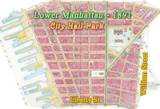
Map of City Hall Park and Lower Broadway - 1905
From Duane Street (north) to Mail St. at Post Office.
Map of the City Hall Park area and Lower Broadway, Manhattan in parts, from White Street, to the north, to Bowling Green, to the south. Published by Sanborn Map Company, Insurance maps of N.Y., 1905. Source: Atlases of New York City from the New York Public Library.
These maps shows Lower Broadway, Park Row, Nassau Street, Whitehall St., State St., Chambers St., Franklin St., Leonard St., Worth St. and several others streets. They include buildings and some of its architectural and construction details, street names and numbering, hydrants and much more. Map key with additional information is below.
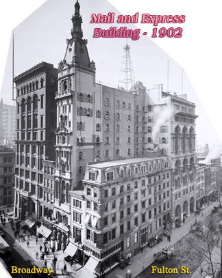
Among the historic buildings, there are the City Hall, Post Office, Stewart Building, Hall of Records, Court House, Astor House, St. Paul Chapel, Mail & Express Building, Park Row Building, Temple Court, Potter Building, Produce Exchange, Kemble Building, U.S. Army Building, Centennial Building, Metropolitan Street Railwat Co., U.S Custom House, German Lutheran Emigrants Home, Hungarian Emigrants Home, Chesebrough Building (Pearl Street), Maritime Building and many others.
More maps from the same Atlas:

West side Broadway from White St. (north) to Duane St.

From Post Office (north), Park Row to Cortlandt Street.

Beginning of Broadway at Bowling Green (north) to South St. / Broadway Street.


East side Broadway from Ann Street to Cedar St.

From Duane Street (north) to Park Place / Post Office.

West side Broadway at Bowling Green / West Street from Rector Street (north) to Battery Place.

Broadway east side from Cedar St. (north) to Wall St. / Broad Street to Beaver St. - 1905.

Broadway from Wall Street (north) to Bowling Green.

West side Broadway from Cortlandt Street (north) to Rector St. / Trinity Place. - 1905.
|
Copyright © Geographic Guide - Old NYC, 19th Century. Historic Maps |

East side Broadway from White St. (north) to Duane St.
Click on the maps to enlarge them.
Map of City Hall Park and Lower Broadway - 1905
