Central Park in a Panorama of New York - 1873
Panorama of New York with Central Park in the foreground. Illustration by George Schlegel. Published by Geo. Degen, ©1873. Print by G. Schlegel, 97 William St. N.Y. Source: Library of Congress Prints and Photographs Division.
In 1853, the New York State Legislature enacted into law the setting aside of more than 750 acres of land in Manhattan Island to create “the Central Park.”, opened in 1876.
The Belvedere Castle on the left was completed in 1869. Bethesda Fountain and Terrace, and the Mall behind it are in the center. The old Lenox Library, on Fifth Avenue, is between 70th and 71st streets. The West 59th Street limits Central Park to the south. The Brooklyn Bridge seen in the distance was planned but not built at the time. It opened to traffic in 1883.


More: Historical maps of New York City ►
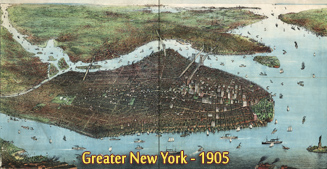

Central Park in a Panorama of New York - 1873
|
Copyright © Geographic Guide - 19th Century NYC. Historical Maps of U.S.A. |