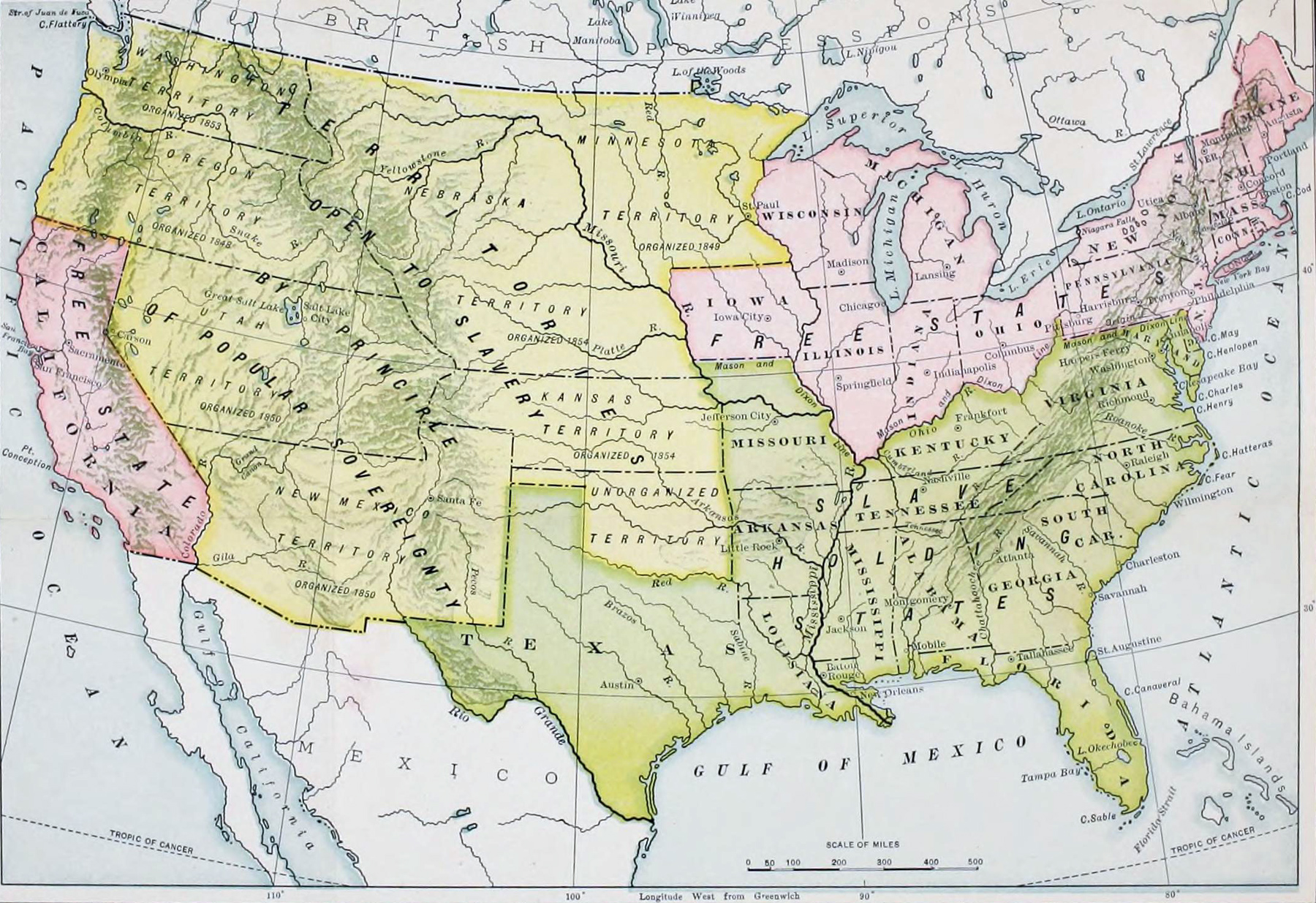
United States of America, Historical Map - 1855
Historical map of the United States of America on March 4, 1855, published in A History of the American People by Woodrow Wilson (1902), then the president of Princeton University and in March 1913, he became the 28th President of the United States of America.
From the Wilson's book: «The elections of 1854 and 1855 brought strange surprises. The Know Nothings won a sudden series of successes. In the autumn of 1854 they elected their candidates for the governorship in Massachusetts and Delaware and put close upon a hundred members into the federal House of Representatives. In the autumn of 1855 they carried New Hampshire, Massachusetts, Rhode Island, Connecticut, New York, Kentucky, and California, and fell but a little short of majorities in six of the southern States. Their successes filled the House of Representatives and the offices of government in the States with new and unknown men. The House of Representatives which met in December, 1855, was so variously and whimsically compounded of Anti-Nebraska men, Free Soilers, Democrats, southern proslavery Whigs, Know Nothings who favored the extension of slavery and Know Nothings who opposed it, that nothing was certain of it except that it contained a majority against the administration.
But another year (1856) brought the opposition together into a clearly defined "Republican" party, into which all Anti-Nebraska men, whether one-time Democrats or one-time Whigs, whether for a little while Free Soilers or for a still shorter time Know Nothings, were drawn with united purpose. Many things besides Mr. Douglas's revolutionary Kansas-Nebraska bill had given heat and cohesion to their gathering opposition. Before that bill had been introduced the administration had purchased of Mexico (December 30, 1853), through Mr. James Gadsden, of South Carolina, the minister of the United States, forty-five thousand square miles of additional territory, lying at the south of the Gila River, to round out the acquisitions of 1848, the root of controversy and compromise. The year the Kansas-Nebraska Act became law, Mr. Pierce had, moreover, at the solicitation of southern men, directed the American ministers to Great Britain, France, and Spain, Mr. James Buchanan, of Pennsylvania, Mr. John Y. Mason, of Virginia, and Mr. Pierre Soule, of Louisiana, to confer and report to him upon the desirability of the acquisition of Cuba by the United States.»

|
Copyright © Geographic Guide - 19th Century, American Continent. Historical Maps. |
United States of America, Historical Map - 1855