The
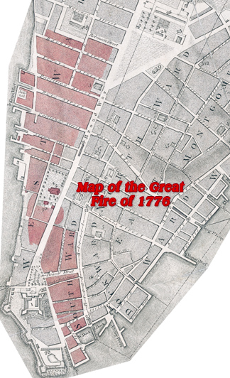
Great Fire of September 21, 1776 happened a few
days after British troops occupied New York City, during the Independence War. It started about 1 a.m. on the eastern side of Broadway, near Whitehall
Slip. Below, some text from Lamb's book that accompanies this map:
«Ere the week which had opened with the roar of artillery came to an end, New York was in Haines. About one o'clock on the morning of Saturday, the 21st, a lire, broke out near Whitehall Slip. A fresh gale was blowing from the south, and the weather was dry, thus if spread with inconceivable rapidity. It coiled itself round building after building like a serpent greedy of its prey. Houses and churches disappeared like dissolving views. The panic-stricken and distracted inhabitants were almost as terrible to behold as the roaring conflagration. Blazing fire-brands leaped along in advance of the lurid column, and little fires were breaking out everywhere. People ran along the streets to see, and the tire went over their heads and flanked them. Even the red heavens seemed also on fire. The British, maddened by the supposition that it was the work of the Americans, visited the most revolting cruelties upon persons who were trying to save property, killed some with the bayonet, tossed others into the flames, and one who, it is said, was a royalist, they hanged by the heels until he died. The wind veering as the great fire-tempest swept up the east side of Broadway, near Beaver Street, it crossed, and presently Trinity Church was a blackened heap of ruins, together with the parsonage, charity school, and Lutheran Church. A number of citizens went upon the flat roof of St. Paul's Church, and extinguished the Hakes of fire as they fell, thus saving the beautiful edifice. All the houses west of Broadway to the North River were consumed, the fire being checked only when it reached the College grounds. The map will show the reader its course and extent. Howe attributed the calamity to a conspiracy. It was generally attributed to incendiaries, and some two hundred persons were arrested upon suspicion and incarcerated. Every person who was known to have talked inconsiderately was seized. Examinations, however, elicited no proofs of guilt, and one after another was liberated. The origin of the fire was subsequently traced to a midnight carousal in a small public house of low character near White-Slip. It is said that the night being chilly, the half drunken beings brought in some boards or rails, and kindled the ends in a large old-fashioned fire-place; the fire creeping along the dry timber soon communicated with the floor. The sequel has been told.»


