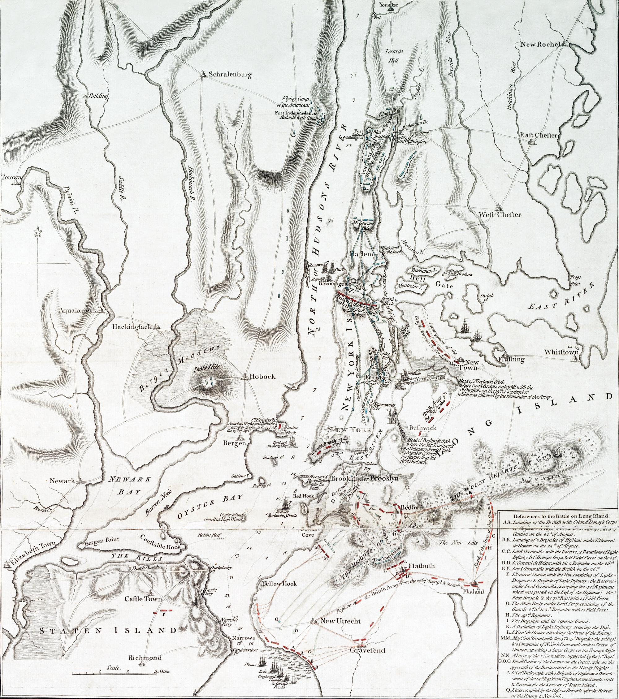
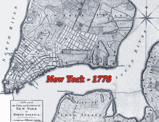
Title: A plan of New York Island, with part of Long Island,
Staten Island & east New Jersey: with a particular description of the engagement
on the Woody Heights of Long Island, between Flatbush and Brooklyn, on the 27th
of August 1776 between His Majesty's forces commanded by General Howe and the
Americans under Major General Putnam, showing also the landing of the British
Army on New-York Island, and the taking of the City of New-York &c. on the 15th
of September following, with the subsequent disposition of both the armies.
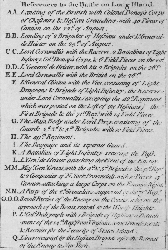
References to the battle on Long Island (bottom right corner of the map). Engraver: William Faden (1749-1836). Publisher: Wm. Faden, successor to the late Mr. Ts. Jefferys, geographer to the King, Charing Cross. Date Issued: 1776-10-19, London. Source: The New York Public Library.
Text in lower margin: "An account of the taking of the city of New York, by His Majesty's forces, on the 15th September, 1776." Taken from Gen. Howe's letter to Lord George Germaine, principal Secretary of State for the American Department. Dated Head Quarters, York Island, September 21, 1776.
"Upon the Rebels abandoning their lines at Brooklyn, the King's army moved from Bedford, leaving Lieut. Gen Heister encamped upon the heights of Brooklyn with two brigades of Hessions, and one brigade of British at Bedford, and took five positions in the neighbourhood of New Town, Bushwick, Hell-Gate, and Flushing.
The two islands of Montresor and Buchannan were occupied, and batteries raised against the enemy's work at Horen's Hook, commanding the passage at Hell-Gate.
On the 15th in the morning, three ships of war passed up the North River as far as Bloomingdale's, to draw the enemy's attention to that side; and the first division of troops, consisting of the light infantry, the British reserve, the Hessians, grenadiers and chasseurs, under the command of Lieut. Gen. Clinton, having with him Lieut. Gen Earl Cornwallis, Maj. Gen. Vaughn, Brig. Gen. Leslie, and Col. Donop, embarked at the head of New-Town Creek and landed about noon upon New York island, three miles from the town, at a place called Kepp's Bay, under the fire of two 40 gun ships; and three frigates, as per margin, Commodore Hotham having the direction of the ships and boats.
The Rebels had troops in their works round Kepp's Bay, but their attention being engaged in expectation of the King's troops landing at Stuyvesant's Cove, Horen's Hook, and at Harlem, which they had reason to conclude, Kepp's Bay became only a secondary object of their care. The fire of the shipping being so well directed, and so incessant, the enemy could not remain in their works, and the descent was made without the least opposition.
The conduct of the officers of the navy does them much honour; and the behaviour of the seamen belonging to the ships of war and transports, employed to row the boats, was highly meritorious. Much praise in particular is due to the Masters and men of six transports, that passed the town on the evening of the 14th under heavy fire, being volunteers, to take troops on board for the more speedy disembarkation of the second division.
The British immediately took post upon the commanding height of Inclenberg, and the Hessians moving towards New York, fell in with a body of Rebels that were retiring from Stuyvesant's Cove; some firing ensued, by which a Brig. Gen. Other Officers, and several men of the Rebels were killed and wounded, with the loss of four men killed, and eight wounded, on the part of the Hessians.
As soon as the second embarkation was landed, the troops advanced towards a corps of the enemy upon a rising ground three miles from Inclenberg, towards King's Bridge, having McGowan's pass in their rear, upon which they immediately retired to the main body of their army upon Morris's Height.
The enemy having evacuated New York soon after the army landed, a Brigade took possession of the works in the evening. The prisoners made in the course of this day were about 20 officers and 300 men.
The position the King's army took, on the 15th in the evening, was with the right to Horen's Hook, and the left at the North River near to Bloomingdale; the Rebel army occupying the ground with extensive works on both sides of King's Bridge, and a redoubt with cannon upon a height on the west side of the North River, opposite to the Blue Bell, where the enemy have their principal work; in which positions both armies still continue.
On the 16th, in the morning, a large party of the enemy having passed under cover of the woods, near to the advanced posts of the army, the 2d and 3d battalions of light infantry, supported by the 42d regiment, pushed forward, and drove them back to their entrenchments, from whence the enemy, observing they were not in force, attacked them with near 3000 men, which occasioned the march of the reserve with two field-pieces, a battalion of Hessian grenadiers, and the company of chasseurs, to prevent the corps engaged from being surrounded; but the light infantry, and the 42d regiment, with the assistance of the chasseurs and field-pieces, repulsed the enemy with considerable loss, and obliged them to retire within their works. The enemy's loss is not ascertained; but from the accounts of deserters it is agreed, that they had not less than 300 killed and wounded, and among them a Colonel and Major killed. We had eight Officers wounded, most of them very slightly, 14 men killed, and about seventy wounded." More: Maps of NYC - 18th Century ►


