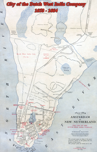
 The
Dutch West India Company established an European settlement, in 1624, named New Amsterdam (Dutch: Nieuw Amsterdam),
now New York, in Noten Eylandt (now Governors Island). In 1626, the Dutch settlement’s governor,
Director-General Peter Minuit, bought the Manhattan Island from the Lenape
people and the settlement was moved to the tip of the Island, where the Fort
Amsterdam was built.
The
Dutch West India Company established an European settlement, in 1624, named New Amsterdam (Dutch: Nieuw Amsterdam),
now New York, in Noten Eylandt (now Governors Island). In 1626, the Dutch settlement’s governor,
Director-General Peter Minuit, bought the Manhattan Island from the Lenape
people and the settlement was moved to the tip of the Island, where the Fort
Amsterdam was built.
In 1637, William Kieft replaced Walter Van Twiller as Director-General. During Kieft's term, tensions with Indians increased, with frequent damage both to people and the cattle. On March 31, 1644, Director-General Kieft and the provincial council decreed that a fence, palisade or clearing should be built from the Great Bouwery (east) to Emanuel Pietersen's plantation (west).
In 1647, Peter Stuyvesant, the last of the Dutch governors arrived in New Amsterdam. In the fall of 1652, began the First Anglo-Dutch War, which ended in 1654 by the Treaty of Westminster.
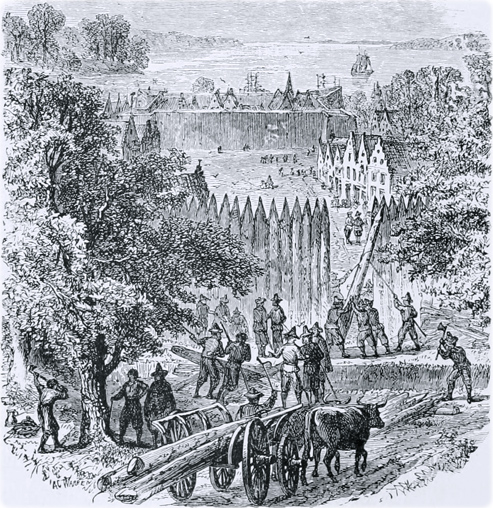
On March 13, 1653, Stuyvesant, the provincial council of New Netherland, the burgomasters and schepens (a kind of alderman in Dutch-speaking regions) of New Amsterdam met in general session. They had received news from New England, concerning preparations for war. The council resolved to prepare for the defense of the city by establishing a burgher night watch at designated locations, repairing and reinforcing the fort, and surrounding most part of the city with a high palisade (palisaden) and a small parapet. The meeting provided that Skipper Jan Jansen Visscher be given secret instructions to prepare his ships, loaded with artillery pieces, in case of emergency. On the same day, a list of contributions was fixed upon by the burgomasters and schepens for the defense expenses. The next day it was decided that the palisade should be built first and then put the fort in a suitable defensive condition as a place of retreat.
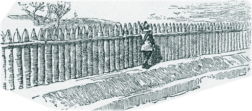
On March 15, the specifications of the palisades were initially established as 12 feet long, 18 inches in circumference, sharpened at the upper end and be set in line. At each rod a post 21 inches in circumference was to be set, to which rails, split for this use should be nailed one foot below the top. The breastwork against it should be 4 feet high, 4 feet at the bottom and 3 feet at top, covered with sods, with a ditch 3 feet wide and 2 feet, 2½ feet within the breastwork. The length of the ground to be lined with palisades was 180 rods.
After conferring the costs, however, the committee agreed to set it off with planks, instead of palisades and the revised specifications were: 180 rods make 2340 feet (710 m), 15 feet to the plank make 156 planks in length, 9 planks high (2.7 m), altogether 1404 planks.
On March 19, the committee gave notice by public outcry that bids would be received the next day at the City Hall for the delivery of 300 to 350 posts, 12 to 13 feet long. They were to be oaken posts, 20 inches in circumference in the middle and 300 split rails, 11 Dutch feet long, 3 to 4 inches thick. Thomas Baxter, an Englishman, agreed to deliver all said posts and rails for 20 stivers for each post rail together (later, the same year, Baxter was pursued and captured for leading English pirates who committed depredations in New Netherland).
On April 20, 1653, the provincial council of New Netherland resolved that all citizens without exception should begin immediately digging a ditch from the East river to the North river, 4 to 5 feet deep and 11 to 12 feet wide at the top sloping in a little towards the bottom; that the carpenters should be urged to prepare jointly the stakes and rails.
On May 12, compulsory service was established by law. Stuyvesant and the council met with the burgomasters and schepens and issued an ordinance to carry out the plan for fortifying New Amsterdam with palisades. The ordinance provided for the distribution of manual labor on the construction work among the inhabitants by means of rotation in four divisions of three-day shifts until completion, which was done in July.
 These
palisades crossed Manhattan from river to river, passing along the north side of
present Wall Street, with a bank of
earth on the inside. Cannons were planted on the outer works (werken),
along the palisades, but, in June 1654, Stuyvesant instructed they should be
removed to the fort for fear that they could be turned against the city, but the
first Anglo-Dutch War ended that year without hostilities in New Amsterdam.
These
palisades crossed Manhattan from river to river, passing along the north side of
present Wall Street, with a bank of
earth on the inside. Cannons were planted on the outer works (werken),
along the palisades, but, in June 1654, Stuyvesant instructed they should be
removed to the fort for fear that they could be turned against the city, but the
first Anglo-Dutch War ended that year without hostilities in New Amsterdam.
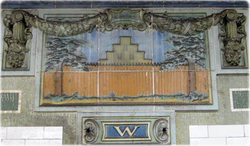
This was the City Wall, that gave its name to Wall Street (renamed officially in 1686, although the name was commonly used before by the English). The Dutch called it werken (works) or palisaden (palisades) and Wall Street was called Het Cingel, Single or Singel. These terms designated both, the canal and the palisades. This is archaic Dutch and there is no correct way to spell it, plus the Dutch spoken in Amsterdam was somewhat different from that spoken in other parts of the Netherlands. Singel is used both in French and Dutch to designate a type of city defense in the Middle Ages, which included a canal surrounding the city, embankments and sometimes palisades. There were singels in Amsterdam, Leyden, Utrecht and Antwerp, for example, and some cities still maintain their canals today. Het Singel could be loosely translated as "the belt". The word derives from Latin cingulum (belt).
In September, 1655, after attacks by Indians, the City Wall was again considered in need of repair and reinforcement. The "erected works" was repaired with plank 5 @ 6 feet high, nailed to the sides of the palisades. The works were completed by the end of the month.
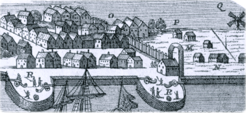
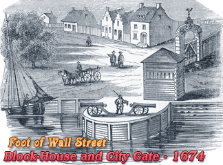
In February, 1656, the bank on the East River, near the City gate (at the present Pearl and Wall streets), was in bad condition and it was deemed necessary to build a firm sheeting of thick plank or boards and raise the fence. A large gate (the Water Gate / Dutch Water Poort], designed by Captain Fredrick de Koningh, was also built (see Duke's Plan). A second gate existed at the continuation of Broadway, the Land Gate (Land Poort).
In October 7, 1656, the owners of gardens near the city gate, by the East River, were ordered to set back their fence because it was standing too near the City wall. This was deemed necessary so that wagons and horses could conveniently pass.
On August 19, 1657, Stuyvesant presented a proposal to the council for enclosing the city at the river side with palisades. On May 25, 1658, the provincial council established that the city of New Amsterdam be enclosed with palisades, having two or three openings or gates, to prevent smuggling.
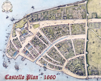
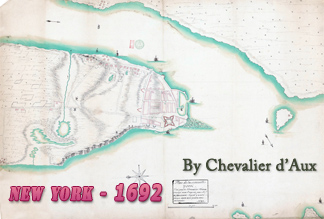
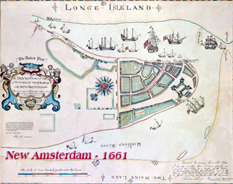
The Castello Plan of 1660 shows a good top view of the City Wall, with an extension to the south along the North River waterfront and nine bastions, some with cannons. The English took control of New York in September 1664 and the City Wall was expanded and improved. Two large stone bastions were constructed on the City Wall, protecting the northern side of the city at Wall Street. One at west of William Street and the other at east of Broadway. Several lots were granted to the English outside the City Wall.
In August 1673, the Dutch retook the city during the Third Anglo-Dutch War. New York was renamed New Orange and the wall was again reinforced. The stone bastions were named "Bastion Zeelandia" and "Bastion Hollandia". These bastions were demolished in 1699 and the stones were employed in building the new City Hall. In October 1673 the Dutch Governor ordered to demolish some houses and the Lutheran Church for "lying right under the fortifications [the wall]" and build another temple inside the City gates.
The Treaty of Westminster was ratified by the Dutch on March 5, 1674, giving the official ownership of Manhattan to the English, but the Dutch occupation lasted until October 31, 1674.
In November, 1688, the Land Gate was said to be "ready to fall down" and the Water Gate was already down. Several other defense structures were ruined. In 1689, repairing the fortifications was among the priorities. In August, 1694, Mayor De Peyster proposed "the Selling of the Vacant Lotts beginning att the West Side of the Wall Street, and running to the Extent of Castor Luersons Ground" for the payment of the city debt. The Common Council approved. A map of 1718 shows that many properties on the north side of Wall Street (where the City Wall stood) belonged to De Peyster family.
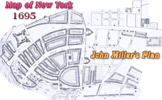
In the late 17th century the City Wall encircled most of the city. The John Miller's Plan of 1695 shows the entire City Wall, but it was probably in bad condition and the city was growing northwards. It is possible that it was demolished in phases, between 1695 and 1699. The Trinity Church, which was located outside the City Wall, began to be erected in March, 1696 and opened opened in March, 1698.
On August 18, 1699, a petition of the Common Council, regarding the appropriation of stone to build the new City Hall on Wall Street, it was reported " That the former linee of fortifications that did Range Along the Wall Street from the East to the North River together with the Bastians that were thereon Erected are fallen to decay and the Incroachment of Buildings which have been made Adjacent thereunto will Render ye Same Useless for ye time to Come". The old City Hall began to be constructed in September 1699, on the north side of Wall Street "fronting the line of fortifications". For that purpose, the governor's council ordered the demolition of the two bastions on September 7.