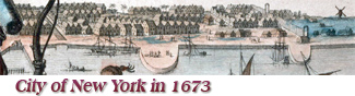
 This is an inset known as "Restitutio View",
color version, from an eastern coast map of North America (known as "Restitutio
Map"), showing New York (New Amsterdam)
at the time it was recaptured by the Dutch on August 24, 1673. Original
title of the view: Nieuw-Amsterdam onlangs Nieuw Jorck Genaemt, en nu
hernomen by de Nederlanders op den 24 Aug 1673. Main buildings and places are identified on the bottom of the
drawing.
This is an inset known as "Restitutio View",
color version, from an eastern coast map of North America (known as "Restitutio
Map"), showing New York (New Amsterdam)
at the time it was recaptured by the Dutch on August 24, 1673. Original
title of the view: Nieuw-Amsterdam onlangs Nieuw Jorck Genaemt, en nu
hernomen by de Nederlanders op den 24 Aug 1673. Main buildings and places are identified on the bottom of the
drawing.
In September of 1664, English forces took control of
New
Amsterdam and the city was renamed New York. On August 24, 1673, began a brief
Dutch reoccupation and the city was renamed New Orange. In 1674, the Treaty of Westminster was signed, giving the official ownership
of Manhattan to the English. Although the Treaty was ratified by the Dutch on
March 5, the Dutch occupation lasted until October 31, 1674.
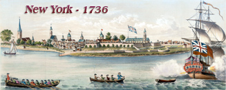
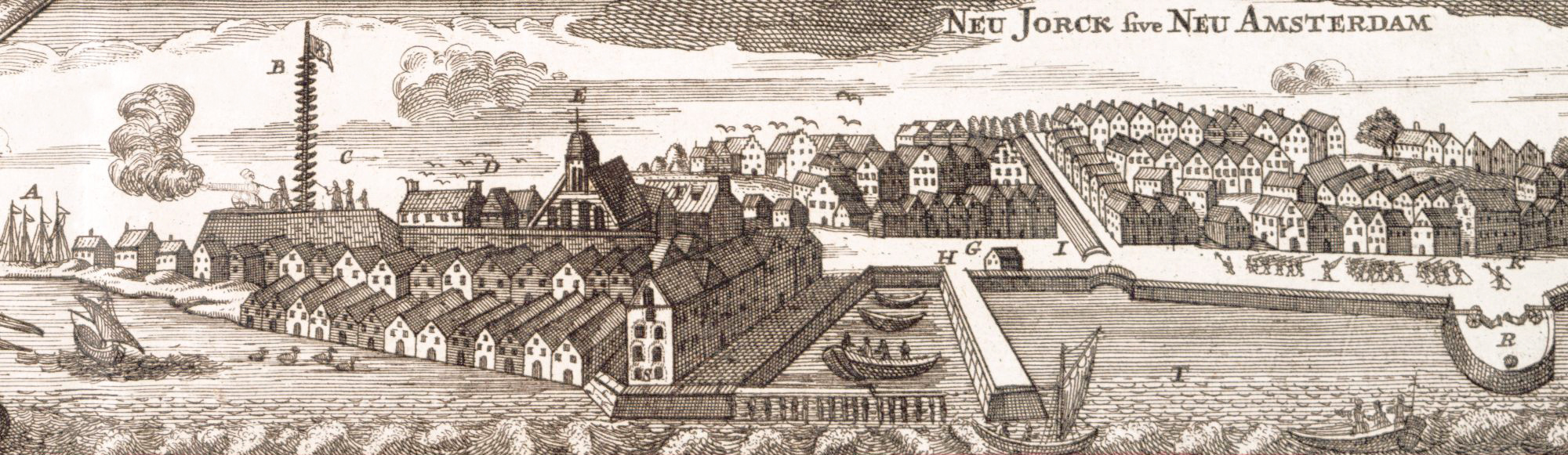
Below, another color edition of the same view above. This is
also an inset from an eastern coast map of North America
(known as the Seutter Map), showing New York (New Amsterdam) depicted in 1673.
Original title: Neu Jork sive Neu Amsterdam. Title
of the full map: Recens edita totius
Novi Belgii, in America septentrionali (Recent publications of the whole of
New Belgium, in North America). It was engraved by Matthaeus Seutter (1678-1756)
and published about 1730. Source: The
New York Public Library.
Enlargements and reference keys of the points of interest are below.
Reference keys of the points of
interest. Dutch (references from the top illustration) / Latin (references
from the second illustration) / Translation in English:
A −
Fort Orangiensche oft N. Albanische Jachten / Castellum Oraniense vel N.
Albanenses Celoces / Fort Orange or New Albany sloops. There are five of
these sloops, whose sails may be seen to the southwest of the fort, anchored in
the Hudson River.
B −
Vlagge-spil, daer de vlag wordt opgehaelt, alssercomen Schepen in dese Haven
/ Pertica cui Aplustria vel vexilla imponurctur quando naves portum intrant
/ Staff upon which pennants or flags are hoisted when ships enter port. The
flagstaff had little steps or crosspieces nailed on it at regular intervals to
help the Dutchman reach the top, where he watched for ships coming into the bay.
C −
Fort Amsterdam, genaemt Jeams-fort by de Engelsche / Propugnaculum Amsterdam,
ab Anglis Jeams fort dictum / Fort Amsterdam, by the English called Fort
James. The Fort was first built in 1626 and finished in 1635. It was known as
Fort Amsterdam until 1664, when it was called "James Fort". From 1673 to 1674 it
was officially referred as "Fort William Hendrick". From 1674 to 1689 it was
again known as "Fort James". From 1689 to 1691, it was called "Fort William".
From 1702 to 1714 it was called "Fort Anne" and from 1714 till after the
Revolution it was called "Fort George". It was demolished in 1790.
D −
Gevangen-huys / Domus Captivorum / Jail. It was built by Governor Kieft
in the Fort and was used for prisoners of the West India Company, and a part of
the City Hall was used as a jail for the burgher prisoners.
E −
Gereformeede kerck / Templum Reformatorum /
Reformed Church.
The Church in the Fort is depicted with a single roof, and a belfry on its
southern gable. This change from the double-peaked roof was probably made in
1672, when the city voted an appropriation to repair the church roof. This
church was built in 1642 and dedicated to St. Nicholas.
F −
Gouverneurs-Huys / Domus Gubernatoris / Governor's House. It
was built by Governor Kieft, being 100 feet long, 50 feet wide, and 24 feet
high.
G −
'tmagazyn / Granarium publicum / Public Storehouses.
H −
de Waeg / Trutina publica / Public Scales or the Weigh-house. In
1653 the Dutch West India Company granted to the citizens the right to erect a
weigh-scales at the wharf. This building was erected at the northerly side of
the long dock extending out into the East River, between Whitehall and Broad
streets. This dock, called the "Hooft" by the Dutch, was extended in 1659, and
again extended four rods farther in 1660 and renewed in 1667.
I −
Heeren-gracht
/ Dominorum Fossa / The Great Ditch (now Broad Street). This is the first
view to show the Heere Graft with the walls of the canal completely sheathed.
The
existing
inlet was enlarged into
a canal, known as Heere
Graft or Heeren Gracht,
completed in 1659
and streets were
extended on both sides. In 1671, the work of building up the sides
of the ditch was extended as far as Tuyen
Straat (now Exchange Place). In 1676, the canal was filled
in.
K −
Stadt huys / Curia / State House or
City Hall. This building was located at the site which is now the head of
Coenties Slip. The view also shows the tavern built by Lovelace, in 1670, just south of
the City Hall, depicted here without a cupola, which must be an error as we know
from the Castello Plan that one existed before
this time. It was possibly added shortly after January 24, 1656, when the
burgomasters petitioned Stuyvesant for the bell which stood "idle in the Fort,
either as a present or on valuation, to hang it, and make use of it, at the City
Hall".
L −
Luthersche Kerck / Templum Lutheranorum /
Lutheran Church. The firs temple
of the Lutherans was built in 1671 on the site of the present Trinity Church,
outside the city walls. It was demolished in 1673 and the second Lutheran temple
was built inside the walls a few years later.
M −
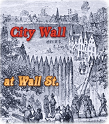
Waterpoort / Porta Aquatica / Water Gate or the Northeast gate (Foot
of Wall Street). The waterfront near Wall Street was not fully completed
before 1679.
N −
Smidts-valley / Fabrorum arca / Smith's Valley or Smith's Fly.
This was the name of what is now Pearl Street, between Wall Street and Franklin
Square. It was known by this name as early as 1639. In 1674 there were 24 owners
of property between Franklin Square and Wall Street on Smith's Valley.
O −
Landpoort / Porta Continentem versus / Land Gate (on what is now Broadway
and Wall
Street).
P −
Weg na 'tversche water / Via ad aquam dulcem / The Way to the
Fresh Water. This was the road leading to the fresh-water pond called the
Collect, a corruption of Caleb Hook, which was situated at where Broadway and
Canal Street now are. The Way to the Fresh Water become part of Broadway.
Q −
Wint-molen / Mola alata / Windmill. This is probably the windmill
of Peter Jansen Mesier. A windmill was erected in 1662 on Broadway between
Liberty and Cortlandt streets.
R −
Ronduyten / Propugnacula / Small fortifications. Three fortified
roundouts or piers (exaggerated in size) are shown, corresponding with the
statement in the Description of the Towne of Mannadens,
1661 (in Jameson’s Nar. N. Neth.): "they then said they would build 2 halfe
moons more between yt [the Stadt Huys] and the Northeast gate". The
half-moon in front of the City Hall was repaired in July, 1672. This was called
the " Stadt Huys Battery." The one between this battery and Wall Street was
called the " Burgher Battery," and the half-moon at the foot of Wall Street was
called the " Wall Street Battery."
S −
Stuyvesants Huys / Domus Stuyvesantii / Stuyvesant's House. It
appears at the foot of Whitehall Street and was built by Governor Peter
Stuyvesant some time prior to 1658, in which year the city authorities confirmed
his title to the property.
T −
Oost-Rivier, lopende tusschen 't Eylant Manhatans, en Jorckshire oft
"t lange Eylandt / Fluvius Orientalis currens inter insulam Manhattans in Jorck
Shire vel Ins. longa / The East River, flowing between Manhattan Island and
Yorkshire or Long Island.