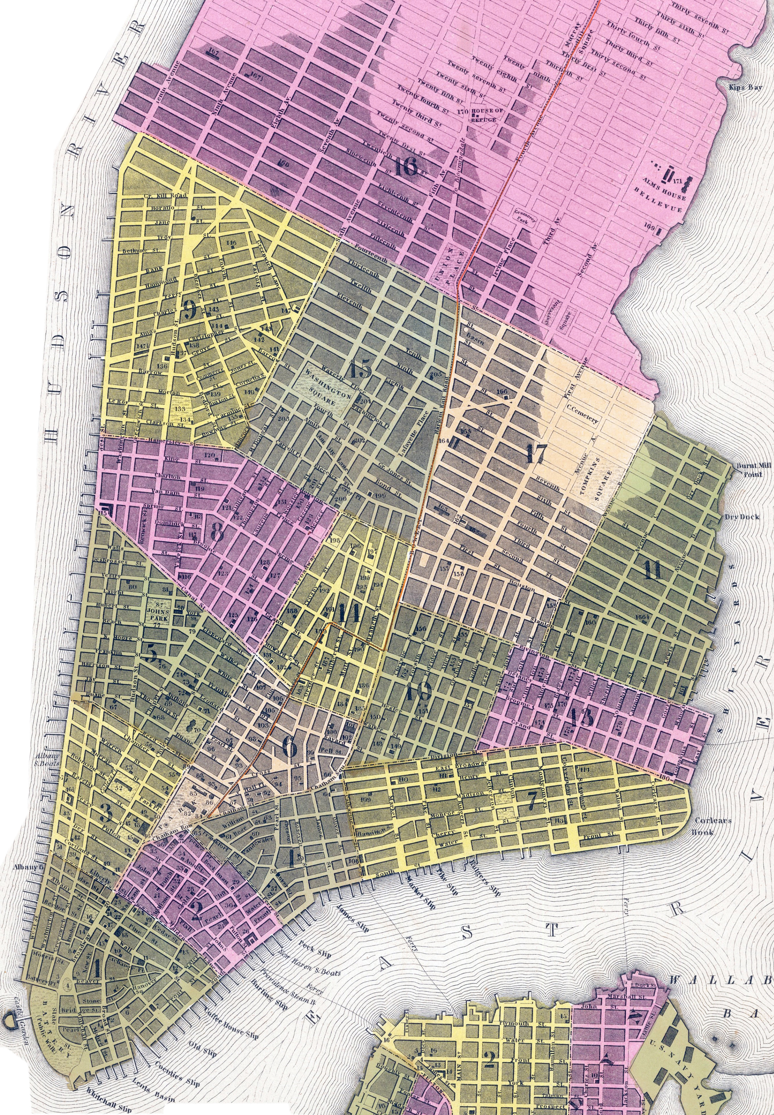
Map of New York City, H. N. Burroughs - 1846
Hand colored map of Lower Manhattan, copyright 1846 by H.N. Burroughs, published by Samuel Augustus Mitchell in 1847 (from his New Universal Atlas), Philadelphia. Original title: City of New York. Note: the original map was cropped to better fit this web page. Source: Barry Lawrence Ruderman Antique Maps Inc.
H.N. Burroughs was an engraver based in Pennsylvania and active in the first half of the 19th century. The publisher S. Augustus Mitchell was born in Connecticut, in 1792, and moved to Philadelphia about 1830, where he established his publishing business.
This map has some references that did not exist in 1846, like the Adelphi Hotel on Bowling Green, destroyed in the Great Fire of 1845, and the South Dutch Church on Exchange Place, destroyed in the Great Fire of 1835 and not reconstructed.
REFERENCES. Public Buildings, Squares & Markets ― Nº / Ward.
• Academy of Arts ― 48 / 3.
• Academy of Design ― 35 / 2.
• Alms House ― 171 / 16.
• Arsenal ― 104 / 6.
• Atheneum ― 55 / 3.
• Baths ― 93 / 6.
• Bowery Theatre ― 101 / 6.
• Bowling Green ― 4 / 1.
• Bridewell ― 85 / 6.
• Catherine Market ― 108 / 7.
• Cemeteries ― 163 / 17.
• Centre Market ― 189 / 14.
• Chatham Square ― 66 / 4.
• City Hall ― 82 / 6.
• City Public Yard ― 103 / 6.
• Clinton Market ― 115 / 8.
• College of Physicians ― 38 / 2.
• Columbia College ― 38 / 2.
• Custom House ― 18 / 1.
• Dispensary ― 106 / 6.
• Episcopal School ― 116 / 8.
• Episcopal Theological Seminary ― 167 / 16.
• Episcopal Cemetery ― 133 / 9.
• Essex Market ― 154 / 10.
• Fever Hospital ― 169 / 16.
• Franklin Market ― 7 / 1.
• Franklin Square ― 58 / 4.
• Fulton Market ― 26 / 1.
• Gas Works ― 183 / 14.
• Gas Works ― 183 / 14.
• Gas Works ― 183 / 14.
• Governour Market ― 113 / 7.
• Greenwich Market ― 147½ / 9.
• Grand Street Market ― 180 / 13.
• High School ― 188 / 14.
• High School ― 192 / 14.
• House of Refuge [Madison Sq.] ― 170 / 16.
• Jefferson Market ― 147 / 9.
• Masonic Hall ― 96 / 6.
• Mechanics Institution ― 87 / 6.
• Merchants Exchange [Wall Street] ― 11 / 1.
• New York Hospital ― 70 / 5.
• New York University ― 204 / 15.
• Niblos Garden ― 198 / 14.
• Northern Dispensary ― 143 / 9.
• Opera House ― 73 / 5.
• Orphan Asylum ― 146 / 9.
• Orphan Asylum Ro. Cath. ― 195 / 14.
• Park Theatre ― 36 / 2.
• Peales Museum ― 54 / 3.
• Public School ― 62 / 4.
• Public School ― 112 / 7.
• Public School ― 137 / 9.
• Public School ― 177 / 13.
• Public School ― 193 / 14.
• Public School ― 124 / 8.
• Public School ― 68 / 5.
• Public School ― 201 / 15.
• Public School ― 168 / 16.
• Records Office ― 84 / 6.
• Richmond Hill Theatre ― 119 / 8.
• Rotunda ― 86 / 6.
• St. John's Park ― 77 / 5.
• State Public Yard ― 105 / 6.
• Tomkins' Market ― 164 / 17.
• Washington Market ― 46½ / 3.
Note [on print, for the references indicated below]: "The City of New York is divided into Districts called wards which are indicated by the large figures. The first column of figures in the tables refer to the Public Buildings &c. and the second column to the Wards."
CHURCHES. Episcopal ― Nº / Ward.
• All Saints ― 114 / 7.
• Ascension ― 181 / 14.
• Christ's ― 71 / 5.
• City Mission ― 60 / 4.
• Grace ― 14 / 1.
• St. Esprit French ― 75 / 5.
• St. Clement's ― 203 / 15.
• St. George's ― 29 / 2.
• St. John's ― 78 / 5.
• St. Luke's ― 136 / 9.
• St. Mark's ― 166 / 17.
• St. Paul's ― 45 / 3.
• St. Peter's ― 167½ / 16.
• St. Philips Afri. ― 98 / 6.
• St. Stephen's ― 152 / 10.
• St. Thomas ― 200 / 15.
• Trinity ― 16 / 1.
• Zion ― 99 / 6.
CHURCHES. Presbyterian ― Nº / Ward.
• African ― 61 / 4.
• Allen Street ― 151 / 10.
• Associate ― 126 / 8.
• Associate ― 132 / 8.
• Bleecker Street ― 199 / 15.
• Bowery ― 185 / 14.
• Brick ― 37 / 2.
• Canal Street ― 125 / 8.
• Cedar Street ― 19 / 1.
• Central ― 191 / 14.
• Chatham Street ― 92 / 6.
• Eighth ― 144 / 9.
• First ― 17 / 1.
• First Free ― 43 / 3.
• Fourteenth ― 76 / 5.
• Laight Street ― 81 / 5.
• Murray Street ― 53 / 3.
• North ― 140 / 9.
• Reformed ― 88 / 6.
• Reformed ― 142 / 9.
• Rutgers ― 111 / 7.
• Scotch ― 22 / 1.
• Scotch ― 97 / 6.
• Second Avenue ― 162 / 17.
• Second Free ― 92 / 6.
• Seventh ― 175 / 13.
• Spring Street ― 118 / 8.
• Union ― 196 / 14.
• West ― 196 / 14.
CHURCHES. Methodist ― Nº / Ward.
• First Episcopalian ― 61 / 4.
• Second Episcopalian ― 149 / 10.
• Third Episcopalian ― 67 / 5.
• Fourth Episcopalian ― 155 / 10.
• Fifth Episcopalian ― 178 / 13.
• Sixth Episcopalian ― 139 / 9.
• Seventh Episcopalian ― 165 / 17.
• Eighth Episcopalian ― 166½ / 11.
• Ninth Episcopalian ― 128 / 8.
• Protestant Independent ― 122 / 8.
• Protestant Independent ― 173 / 13.
• Protestant Independent ― 190 / 14.
• Primitive Independent ― 117 / 8.
• Primitive Independent ― 160 / 11.
• Independent ― 100 / 10.
• Mariners' Independent ― 59 / 4.
• Asbury Independent African ― 184 / 14.
• Zion Independent African ― 72 / 5.
HOTELS ― Nº / Ward.
• Adelphi Hotel [destroyed in 1845] ― 9 / 1.
• American Hotel ― 50 / 3.
• Astor House ― 46 / 3.
• Atlantic Hotel ― 3 / 1.
• Barclay Str. House ― 51 / 3.
• Broad Str. House ― 2 / 3.
• Bunckers Mansion House ― 8 / 1.
• City Hotel ― 20 / 1.
• Clinton Hotel ― 38 / 2.
• Congress Hall ― 23 / 1.
• Eastern Pearl Street Hotel ― 20 / 2.
• Exchange Hotel ― 15 / 1.
• Franklin Hotel ― 44 / 3.
• Holt's Hotel ― 25 / 2.
• Merchants Hotel ― 1/ 1.
• New York Hotel ― 39 / 3.
• Niblos Hotel ― 21 / 1.
• Orange Co. House ― 42 / 3.
• Pearl Street House ― 6 / 1.
• Tammany Hall ― 65 / 4.
• Tontine Coffee House ― 12 / 1.
• United States Hotel ― 13 / 1.
• Walton House ― 57 / 4.
• Washington House ― 89 / 6.
• Western Hotel ― 40 / 3.
• York House ― 41 / 3.
CHURCHES. Baptist ― Nº / Ward.
• Abyssinian African ― 69 / 5.
• Amity Street ― 202 / 15.
• Beriah ― 121 / 8.
• Bethel ― 156 / 10.
• Brome Street ― 179 / 13.
• East ― 176 / 13.
• Ebenezer ― 159 / 17.
• General ― 131 / 8.
• Mott Street ― 194 / 14.
• Mulberry Street ― 95 / 6.
• Norfolk Street ― 172 / 13.
• North ― 138 / 9.
• Oliver Street ― 64 / 4.
• South ― 31 / 2.
• Union ― 157 / 17.
• Welch ― 157 / 17.
CHURCHES. Reformed Dutch ― Nº / Ward.
• Bleecker Street ― 145 / 9.
• Broome Street ― 127 / 8.
• German ― 148 / 10.
• Greene Street ― 130 / 8.
• Mission ― 158 / 17.
• Middle ― 24 / 1.
• Ninth Street ― 205 / 30.
• North ― 33 / 2.
• North East ― 110 / 7.
• North West ― 74 / 5.
• South [temple destroyed in 1835] ― 10 / 1.
• True ― 120 / 8.
CHURCHES. Miscellaneous ― Nº / Ward.
• Barrow Street (Roman Catholic) ― 141 / 9.
• Christ Church (Roman Catholic) ― 34 / 2.
• St. Mary's (Roman Catholic) ― 174 / 13.
• St. Patrick's (Roman Catholic) ― 197 / 14.
• St. Peter's (Roman Catholic) ― 47 / 3.
• Rose Street Friends ― 63 / 4.
• Henry Street Friends ― 109 / 7.
• Hester Street Friends ― 186 / 14.
• Bleecker Street Friends ― 135 / 9.
• First Unitarian ― 56 / 3.
• Second Unitarian ― 129 / 8.
• First Universalists ― 153 / 10.
• United Friends Universalists ― 91 / 6.
• Independents ― 79 / 5.
• Providence Universalists ― 123 / 8.
• St. James Lutheran ― 187 / 14.
• St. Mathews Lutheran ― 107 / 6.
• German Synagogue ― 182 / 14.
• Portuguese Synagogue ― 5 / 1.
• Moravian ― 32 / 2.
• New Jerusalem ― 94 / 6.
|
Copyright © Geographic Guide - Historic Map 19th Century NYC. |