![]() Comments
about this illustration made by Stokes (iconography of Manhattan Island,
...1918) are shown below:
Comments
about this illustration made by Stokes (iconography of Manhattan Island,
...1918) are shown below:
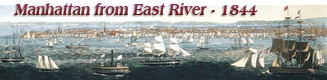
«Second state. The first state has the same imprint except that the publisher’s line reads: “Published by John Bachmann, 5 Rector St. N. York.” The print is otherwise identical except for a fine line framing the rectangle. Impressions of the Williams & Stevens issue exist with the date in the copyright line changed to 1850.
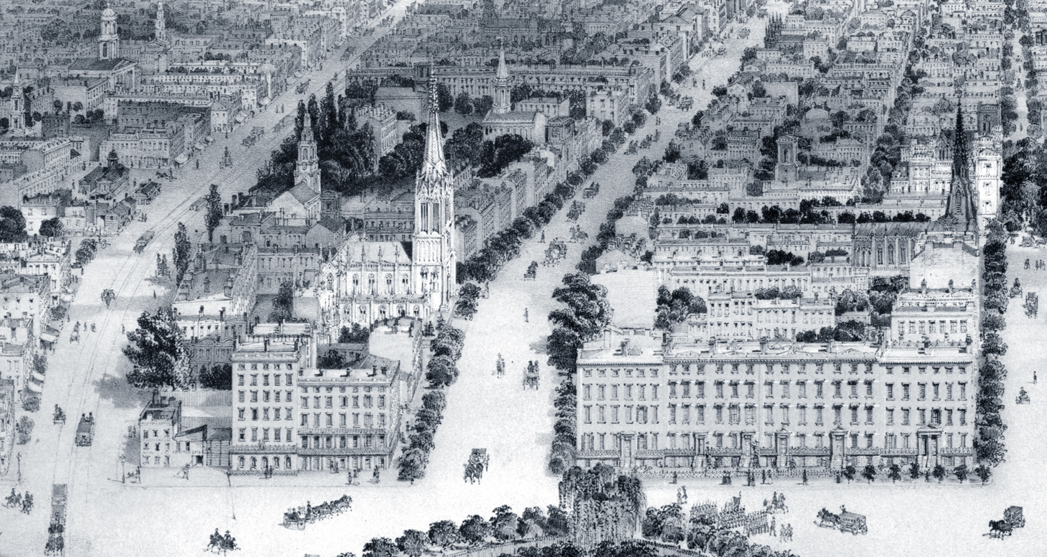
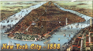
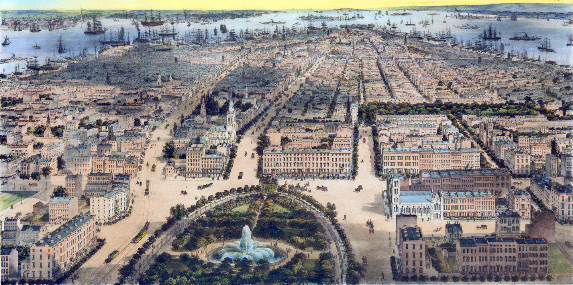
This is a very comprehensive and clear view of the city below Union Square. Practically every important building standing at the time between Union Square and Wall Street can be distinguished. ...
Union Square was created under the Commissioners’ Plan of 1807, on which it appears as ‘Union Place,” and extended from 1oth Street to 17th Street. In 1815, a committee appointed to consider proposals to reduce the size of some of the public squares recommended the discontinuance of Union Place. The junction of Broadway and Fourth Avenue, or, as they were then designated, the Bloomingdale Road and the Bowery, was called “the Forks,” and was partially surrounded during the first quarter of the century by ramshackle old dwellings. For a view of this neighbourhood in 1826, see Addenda. In April, 1831, an act was passed by the Legislature, in compliance with an appeal of the citizens, again creating a park out of the area contained between 14th and 15th Streets, Fourth- Avenue, and the Bloomingdale Road. The limited area was not found satisfactory, as is stated in a resolution adopted by the Board of Assistant Aldermen, on November 7, 1831, reading:
In its present form, Union Place presents to the eye a shapeless and ill-looking place, devoid of symmetry, and is also of too limited dimensions for any purpose for which hereafter it may be not only expedient but necessary to devote it.
An application to the Legislature resulted in the passage of an act, on April 5, 1832, enlarging Union Place to its present size. The iron fence and other improvements were added in 1835 and 1836, and the fountain was constructed in 1842 at the time of the completion of the Croton Aqueduct, and first put in operation on October 14th, the day of the Croton Water Celebration. The iron fence was taken down in 1871.
In 1835 Washington Square and the surrounding streets formed the most fashionable residential quarters of the town. By 1849 this centre of fashion had moved still farther north, and Union Place had become a beautiful residential section. In New York Past, Present and Future (1849), Belden describes Union Place as “surrounded by splendid private mansions, some of which are of costly magnificence, and its vicinity is the most fashionable portion of the city.”
In the block west of Broadway, on the south side of 16th Street, shown in the lower right corner of the view, were the residences of Theodore Putnam, James Suydam, Oswald Cammann, S. F. Tracy, and others. On 15th Street, at the corner of Broadway, which was then called Union Place, was the Church of the Puritans, designed by James Renwick, south of which was a collegiate institution for young ladies, maintained by the Reverend Gorham D. Abbott in the old Spingler Institute. For a time, 15th Street between Broadway and Fifth Avenue, was called Spingler Place after this institute.
The detached Gothic “villa,” in the middle of the block on the north side of 15th Street is still standing (1917), and is known as No. 21 East 15th Street. In 1849, as No. 20, it was in the possession of Oscar Coles, under lease from the Spingler estate. The house was probably erected by Dr. Daniel W. Kissam, a well-known physician, shortly before his death, in December, 1834. The property is now held, partly on lease and partly on deed, by Mr. Richard H. L. Townsend.
The large double house on the north side of 15th Street, just west of the “villa,” was owned by George Washington Browne, proprietor of a hotel at 123-5 Water Street, who sold it, in 1875, to James Stokes and Morris K. Jesup. Two years later the property was transferred to the Y. W. C. A., which occupied the site until June, 1917. The residence on the north-east corner of Fifth Avenue and 15th Street was owned by Daniel B. Fearing. His heirs sold the house, in 1871, to James H. Banker, who in turn sold it, in 1873, to Cornelius Vanderbilt.
South of Washington Square, on Amity Street, near McDougal, is St. Clement’s Episcopal Church, while on Fifth Avenue, north of 10th Street, may be seen the Church of the Ascension and, in the block between 11th and 12th Streets, the First Presbyterian Church. Between 12th and 13th Streets, on Fifth Avenue, at this period, were the residences of Robert B. Minturn, James Lenox, and Mrs. Robert Maitland. Between 13th and 14th Streets were the homes of L. M. Hoffman, August Belmont, and Benjamin Aymar. Residents in the block between 14th and 15th Streets, on Fifth Avenue, included Myndert Van Schaick, Abraham Van Buren, James Brooks, and Henry G. Stebbins.
At No. 71 West 14th Street (north-west corner of Sixth Avenue) was established, in the early ’5o’s, the school of William Forrest (later Forrest and Quackenbos), where so many well-known New-Yorkers of the past generation were educated. Henry James, in his delightful reminiscences of 4 Small Boy and Others, p. 222, refers to his brief connection with this school as follows:
At “Forest’s,” or in other words at the more numerous establishment of Messrs. Forest and Quackenboss, where we spent the winter of 1854, reality, in the form of multitudinous mates, was to have swarmed about me increasingly: at Forest’s the prolonged roll-call in the morning, as I sit in the vast bright crowded smelly smoky room, in which rusty black stove-shafts were the nearest hint of architecture, bristles with names, Hoes and Havemeyers, Stokeses, Phelpses, Colgates and others, of a subsequently great New York salience. It was sociable and gay, it was sordidly spectacular, one was then, by an inch or two, a bigger boy—though with crushing superiorities in that line all round; ...
On the corner of 10th Street and University Place is seen the steeple of the Presbyterian Church, erected in 1845.
The block on 14th Street between University Place and Broadway contained the houses of Charles H. Marshall, James F. Penniman, Frederick Bronson, Robert Kermit, and Cornelius V. S. Roosevelt, who had the house on the corner of Broadway. The tall building in the next block east was the Union Place Hotel, leased at this time to John C. Wheeler. Sheridan Shook leased it in 1871, and called it the Maison Dorée. In 1881 it became known as the Morton House. This building, as well as the one on the south-east corner of Broadway and 14th Street, was owned by Cortlandt Palmer. The corner house on Fourth Avenue was occupied, in 1849, by Francis Mercier, an upholsterer, whose shop was at 156 Fourth Avenue. Between the hotel and the corner house stood the livery stable of Paul D. Burbank.
On the south-east corner of 15th Street and Fourth Avenue was the school of Madam H. D. Chegaray. In the block to the north were the residences of John Griswold, S. B. Ruggles, G. W. Coster, William Kent, John Hicks, Richard Tighe, and, on the corner of 16th Street, J. Fisher Sheafe. The residence of Richard Tighe, still standing in 1896, is shown in a view in Pelletreau’s Early New York Houses, where it is described as the “Last Dwelling on Union Square.”
This entire block (as well as the double houses in which Madam Chegaray’s school was maintained) was erected as a speculation by Samuel B. Ruggles, who had a thirty years’ lease of the property from the Cornelius T. Williams estate. One of the conditions of the lease was that a ten-foot set-back should be left for court-yards. These courts show very plainly in the view.
Grace Church, erected in 1846 on Broadway and 10th Street, is a conspicuous feature; south-east of it appears the steeple of the 9th Street Collegiate Dutch Reformed Church, while St. Mark’s can be seen to the east, surrounded by trees.
The reservoir, on the south side of 13th Street, east of Fourth Avenue, and the Washington Institute, to the left of it, are plainly seen. For a larger view of these two buildings, see Valentine’s Manual for 1853, opposite p. 134.