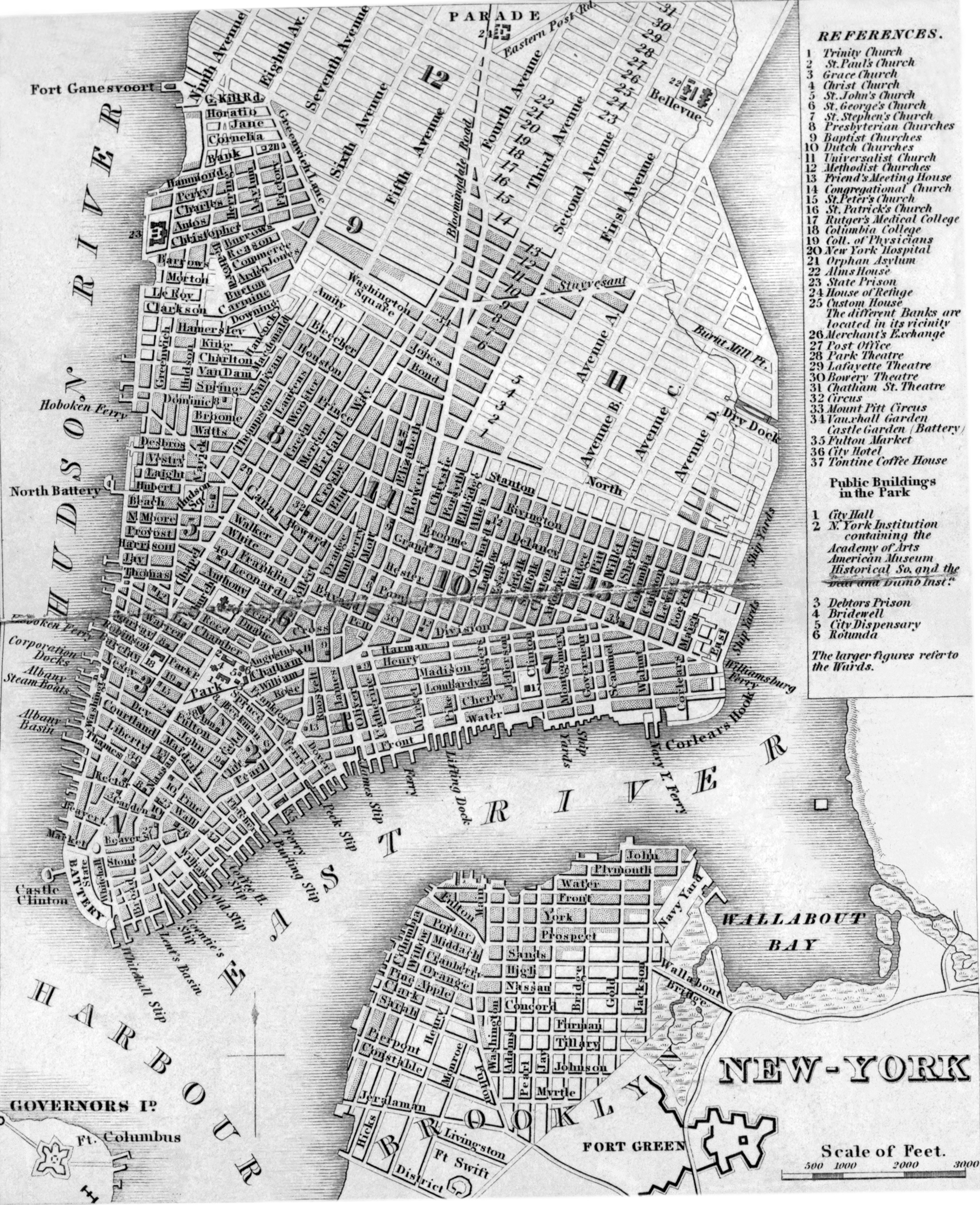
Map of New York City - 1836
Map of the city of New York published in 1838 (copyright 1836) in the The American Traveller ; or Guide through the United States, containing brief notices of the several states, cities, principal towns, canals and rail roads, etc. ; with tables of distances, by stage, canal and steam boat routes ... by Henry Schenck Tanner (1786-1858). Source: New York Public Library. Note: the same map was published by the author in the 1836 and 1837 issues of the book. Below, text published in the book about New York City:
«The commercial emporium of the United States, and metropolis of the state of New York, is situated at the point of junction of the Hudson and East rivers ... The city proper, or that portion where the population is mostly concentrated, occupies the southern quarter of Manhattan island, the whole of which, including Harlaem, Yorkville, and some other villages, is under the jurisdiction of the city corporation, and is identical with the county of New York. The city, together with the suburbs just mentioned, contained in 1830, upwards of 30,000 buildings, and 213,470 inhabitants. The population at this time (1837) may be estimated at 288,000. The densely settled part of the island, or what is called " the city," has an outline of 50,000 feet or ten miles, nearly. Its principal streets are Broadway, in which most of the retail business is transacted, Greenwich street. Pearl street, Broad, Wall and Chatham sts., the Bowery, Maiden-Lane, &c. &c.
The public buildings, and objects of curiosity, are the city hall, in the park, exchange buildings* in Wall street, college, hospital, and Clinton hall, in Broadway ; battery, castle garden, N. Y. Institution, academy of fine arts, alms-house, three theatres, medical college, baths, rooms of the National Academy of Design, masonic hall, in Broadway, house of refuge, orphan's asylum, lunatic asylum, besides many others, and about 100 churches, some of which are very splendid and capacious.
The city government consists of a mayor, ten aldermen, and ten assistants, with an able and effective body of police officers. Steam boats, packets and stages, arrive at and depart from the city, at almost every hour, and for every part of the United States.
* Since the first edition of this work was issued, the Exchange, together with 700 other buildings, have been destroyed by fire [see Great Fire of 1835].


Part of map by John Montrésor.
(Historical So. and the Deaf and Dumb Instn.)
Map of New York City - 1836
|
Copyright © Geographic Guide - Historic Map 19th Century NYC. |